Create an account sign-up-diamond

Start your adventure today.

Already a member? Login

East of Vancouver

Hikes in East of Vancouver

Activities in East of Vancouver

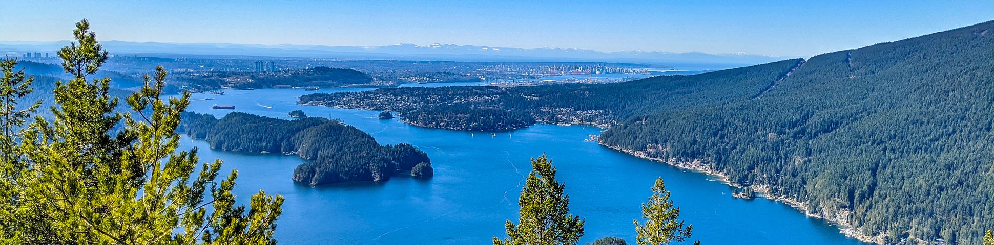
Hiking East of Vancouver is arguably one of the best ways to explore some of the hidden gems of British Columbia’s mountain ranges. Tucked away to the east, you’ll find stunning mountain scenery, a huge selection of hiking trails amongst national parks, pristine lakes and verdant forests to explore. Better yet? You’ll also find little to no crowds.

East of Vancouver encompasses the Coquitlam and Maple Ridge areas, which are often overshadowed by Garibaldi and Whistler. But just a quick drive or train ride from Vancouver will take you east of the city and into an outdoor playground. Home to Golden Ears, Pinecone Burke Provincial Park, Minnekhada Regional Park, Westwood Plateau, Belcarra Regional Park and more—there is no shortage of epic hikes East of Vancouver.

After a full day of hiking, weary travellers can kick up their feet in the city of Coquitlam where trendy bars, cozy restaurants and stylish boutiques are abound. Or if you’re not done exploring yet, set out to explore some of the local city parks in the area to get up close and personal to the unique flora and fauna that can be found East of Vancouver.

Ready to head for the hills (er, mountains!) East of Vancouver? We’ve rounded up the best 10 hikes in the region, so pack your bags and hit the trails in one of Canada’s fastest growing areas.

The 10 Greatest Hikes East of Vancouver

From easy, gentle trails to challenging, heart-pounding summits, East of Vancouver has it all when it comes to hiking. Regardless of which trail you choose, you’ll likely enjoy stunning mountain views and depending on the time of year, trails in full bloom, bursting with colourful wildflowers. For an epic day-hike or multi-day hike, check out the Golden Ears Summit hike, with arguably the best views in all of Vancouver. Or, if you’re in search of a child-friendly outing, the Crystal Falls hike has flat trail that lead to a magnificent waterfall that is sure to delight.

  • Crystal Falls: Crystal Falls hike is a terrific family outing. This easy and flat trail follows the Coquitlam River and ends at a small, magical waterfall.
  • Sendero Diez Vistas: The Sendero Diez Vistas hike is a popular loop. There are ten unique viewpoints (hence, ‘Diez Vistas’), which can be seen on the loop that navigates all the way around Buntzen Lake.
  • Gold Creek Falls: Gold Creek Falls hike an easy trail in Golden Ears Provincial Park. Follow this relatively flat path along Gold Creek, until you reach a beautiful waterfall.
  • Golden Ears: Golden Ears Summit hike is an extremely challenging day hike, where the peak is hard to summit. But those make it will be rewarded with some of the best views anywhere around Vancouver.
  • High Knoll: High Knoll hike is a popular trail in Minnekhada Regional Park. A short hike will take you to a nice bluff overlooking the Pitt River.
  • Jug Island: The Jug Island hike is a fun trail that starts at one beach and leads to another. Jug Island Beach is small, but scenic and you can swim on hot, summer days.
  • Munro Lake & Dennett Lake: The Munro Land & Dennet Lake hike is a perfect trail for those looking for a challenge and avoid the crowds, with two glistening lakes and a stunning scenic lookout.
  • Sawblade Falls: Sawblade Falls hike leads to a small, but scenic waterfall in Pinecone Burke Provincial Park.
  • Steelhead Falls: Steelhead Falls hike is a gentle trail at Hayward Lake that leads to a large waterfall. The hike is easy, but those who want to hike further can make a loop around the entire lake.
  • Widgeon Falls: The Widgeon Falls hike makes for a fun outing, as you have to find a way across the Pitt River to reach the trailhead. The trail itself is mostly flat and easy, and leads to a small, but scenic waterfall.

When Is The Best Time To Hike East of Vancouver

Like most of the trail within British Columbia, peak season for hiking East of Vancouver is between late June to mid-September. The weather is pretty much unbeatable, especially once up in the mountains and the wildflowers are often in full bloom during this period.

However, this is also when the trails are at their peak busy season. Meaning you might find crowded trails and be vying for camping sites and hotel accommodations. If you wish to avoid the crowds, we recommend visiting in either the spring or fall shoulder season, though you may run into some snow!

Some of the trails can also be done all-season, but we recommend checking trail conditions beforehand and ensure you dress warmly.

If you’d like to make a trip East of Vancouver your next getaway, we’ve got all the information you need! Find our comprehensive guide to planning a trip East of Vancouver, with an insider’s tips on the best restaurants, accommodations, cafes and experiences. We’ve taken all the guess work out, so you don’t have to. Now just lace up those hiking boots and hit the trails.

How To Plan A Trip East of Vancouver

If you’d like to make a trip East of Vancouver your next getaway, we’ve got all the information you need! Find our comprehensive guide to planning a trip East of Vancouver, with an insider’s tips on the best restaurants, accommodations, cafes and experiences. We’ve taken all the guess work out, so you don’t have to. Now just lace up those hiking boots and hit the trails.

Frequently-Asked-Questions About East of Vancouver

Are there a lot of bears in Coquitlam?

Yes. Coquitlam is the bear-sighting capital of B.C., so if you are heading into the mountains or even local parks, it’s important to have bear spray on you. Be sure to be bear aware and if you see one, don’t run or turn your back on the bear.

What is the easiest hike East of Vancouver?

If you’re looking for a quick, relatively easy hike, we recommend the Steelhead Falls hike. The path is gentle, with little change in elevation and it leads to a pretty waterfall that makes for a great photo-op.

See Map

Displaying 45 of 48 routes

Route guides for Hiking in East of Vancouver

See Map

0 hours

144 hours

0 km85 km

0

5

0

10

10 overall rating
East of Vancouver

Crystal Falls Route Guide

Crystal Falls is a gentle hike following the Upper Coquitlam River, which ends at the stunning Crystal Falls waterfall on Pritchett Creek. While this is an all-year trail, summer takes this hike to the next level, with crystal clear canyon pools available for a refreshing dip.
Easy
5.6 km
123 m
1.5-2h
10 overall rating
East of Vancouver

Sendero Diez Vistas Route Guide

For a challenging walk around Buntzen Lake, try the Sendero Diez Vistas Trail hike. Find ten incredible viewpoint along the ridge walk, overlooking the North Shore, Burrard Inlet, the Indian Arm and even Vancouver Island.
Moderate
13.6 km
593 m
4-5.5h
10 overall rating
East of Vancouver

Gold Creek Falls Route Guide

Gold Creek Falls hike is a great walk for those camping nearby in Golden Ears Provincial Park or visiting Alouette Lake. With an easy, well-maintained path leading to a beautiful waterfall, this makes for a great family hike.
Easy
5.9 km
105 m
1.5-2h
10 overall rating
East of Vancouver

Golden Ears Route Guide

The Golden Ears Summit is one of the most difficult, yet rewarding hikes in all of the Vancouver region. Located in Golden Ears Provincial Park, this popular hike provides 360 views over stunning vistas and is often completed over two days.
Very Hard
22.0 km
1,574 m
8-11.5h
10 overall rating
East of Vancouver

High Knoll Route Guide

Head to Minnekhada Regional Park to hike to High Knoll for mesmerizing views and plenty of trails to explore throughout. Pass by marshes split into two sections by a dyke, and teeming with local wildlife
Easy
5.3 km
324 m
2-2.5h
10 overall rating
East of Vancouver

Jug Island Route Guide

The Jug Island hike is an easy walk for the whole family through fresh-smelling cedar forests, up the spine of the peninsula. Pass by both Belcarra and Bedwell Bays, where clear, glistening water entices hikers in for a refreshing dip.  
Easy
5.3 km
217 m
1.5-2h
10 overall rating
East of Vancouver

Munro Lake & Dennett Lake Route Guide

For a challenging hike, explore two amazing lakes near Coquitlam, BC: Munro Lake and Dennett Lake, which can be accessed via a steep hike in Pinecone Burke Provincial Park, Coquitlam. Be sure to pack your swimsuit so you can run straight for the water at the end of the hike during the summer months.
Hard
12.5 km
929 m
5-6.5h
10 overall rating
East of Vancouver

Sawblade Falls Route Guide

Explore woodland trails on the Sawblade Falls hike, which leads to a scenic waterfall located on Burke Mountain in Pinecone Burke Provincial Park, Coquitlam. Pass by smaller falls and beautiful alpine forests to enjoy fresh mountain air on the way to the main attraction.  
Easy
9.3 km
333 m
2.5-3.5h
10 overall rating
East of Vancouver

Steelhead Falls Route Guide

The Steelhead Falls hike is an ideal year-round trail with little to no snow due to the low elevation. The waterfall is spectacular and has upper and lower viewing platforms, making the Steelhead Falls a great option for families and solo hikers alike
Very Easy
1.9 km
62 m
0.5h
10 overall rating
East of Vancouver

Widgeon Falls Route Guide

Get ready for some paddling fun, since you’ll need to canoe or kayak to reach the starting point for the Widgeon Falls hike. This trail can be a great all-seasons hike, but is especially spectacular in the fall, as the leaves change colour all along the shallow waters of Widgeon Slough.
Easy
7.3 km
198 m
2-2.5h
No Ratings
East of Vancouver

Burnaby Mountain Park Hike Route Guide

Home to Simon Fraser University, Burnaby Mountain also hosts 17.4mi of hiking trails that make their way throughout the Burnaby Mountain Conservation Area. Enjoy spending the day losing yourself in its network of trails, climbing to the top of the mountain to spot distant peaks, or heading downhill to hit up the mountain bike trails. Don’t forget to check out the wood-carved totems that stand high in the sky near the Horizons restaurant.
Moderate
11.1 km
362 m
3-4h
No Ratings
East of Vancouver

Sasamat Lake Trail Route Guide

The Sasamat Lake Trail is a great lakeside hike where the entire family can enjoy a full day of fun outdoor activities. Take pleasure strolling along the flat trails, soaking in the sun on the beach, or fishing off the floating bridge on the south side of the lake. When the sun gets too hot, jump in the water of one of the warmest lakes in the region, or cool off with a treat from the lakeside concession stand. This popular weekend getaway has something for everyone.
Very Easy
3.2 km
48 m
0.5-1h
No Ratings
East of Vancouver

Evans Peak Trail Route Guide

The hike up to Evans Peak is an ideal day trip for those looking to experience the beauty of Golden Ears Provincial Park, without the full-day/overnight commitment of some of its more well-known attractions. The Evans Peak trail is a challenging experience due to its steep trail and multiple rope sections, but it rewards hikers with beautiful views of Alouette Lake to the south east, and the majestic Garibaldi Provincial Park to the north.
Very Easy
10.5 km
952 m
4.5-6.5h
No Ratings
East of Vancouver

Coquitlam Crunch Trail Route Guide

The Coquitlam Crunch Trail is an urban hiking route purposefully designed to provide hikers with an excellent workout. This steeply inclined 3.9mi trail runs underneath a length of hydropower lines and is often considered a less intense version of the Grouse Grind. So while the route may lack beautiful, unobstructed views, you can rest assured that it more than makes up for this shortcoming with an intense workout that will leave you feeling accomplished.
Easy
6.3 km
257 m
2-2.5h
No Ratings
East of Vancouver

Buntzen Lake Loop Route Guide

The Buntzen Lake Loop is a 7.5mi trail around the shores of Buntzen Lake that passes through beautiful forests and over scenic bridges. Better known now for recreational use than its history producing hydroelectricity, the lake is home to a network of trails and several beaches, offering outdoor enthusiasts several options to get out and enjoy nature. Access to the park is limited, so make sure you get there nice and early to beat the crowds.
Moderate
12.1 km
247 m
3-4h
No Ratings
East of Vancouver

Mundy Park Trail Route Guide

The Mundy Park Trail is a densely-forested hiking path through Coquitlam’s largest park and has little elevation change, making it a great hike for children or beginner hikers. Follow along the Perimeter Trail as it skirts the outside of the park and passes by two lakes. Due to the many sports facilities within the park, this is a great route to pass the time while the kids are at softball practice or to take the dogs for a long, shady walk through the forest.
Very Easy
4.3 km
51 m
1-1.5h
No Ratings
East of Vancouver

Hayward Lake Trail Route Guide

The Hayward Lake Trail is a 10.9mi route near Mission, BC, that loops around Hayward Lake and crosses over two dams - Ruskin Dam in the south and Stave Falls Dam in the north. Travel around the beautiful lakeside scenery on your way to the picturesque Steelhead Falls before ending up at one of the lake’s beautiful beaches. This is a great day hike that offers access to a lot of other fun outdoor activities.
Moderate
17.5 km
387 m
4-6h
No Ratings
East of Vancouver

Alouette Lake Trail Route Guide

The Alouette Lake Trail is a fun 9.5mi out-and-back trail that takes you along a forested path through Golden Ears Provincial Park. This hiking route doesn’t offer much in terms of great views until you get to the South Beach at Alouette Lake, but it does pass through some beautifully forested areas with spectacular flora and fauna. Make sure to pack a swimsuit to enjoy the refreshing waters of the lake.
Easy
15.3 km
264 m
3.5-5h
No Ratings
East of Vancouver

Eagle Mountain Powerline Trail Route Guide

The Eagle Mountain Powerline Road is a fairly easy-going 5.1mi out-and-back route that travels along a clearing in the forest up to a viewpoint over Buntzen Lake. The trail itself doesn’t contain many views, but the wide gravel path offers a gentle uphill climb that is accessible for most skill levels, and the view over the lake is spectacular. This is a straightforward route that makes for an easy afternoon outing.
Moderate
8.2 km
280 m
2-3h
No Ratings
East of Vancouver

Coquitlam Lake View Trail Route Guide

The Coquitlam Lake View Trail is a 6.1mi out-and-back route that passes through Pinecone Burke Provincial Park on the way to a viewpoint overlooking Coquitlam Lake. This trail is largely forested, meaning there won’t be any views until you reach the top, but once you make it to the viewpoint, the sights will not let you down. Take in sweeping views of the picturesque Coquitlam Lake as it sits nestled in a wooded valley below a mountainous backdrop. This trail is a real hidden gem amongst Coquitlam area hiking routes.
Moderate
9.8 km
601 m
3.5-5h
No Ratings
East of Vancouver

Admiralty Point Trail Route Guide

The Admiralty Point Trail is a short 3.3mi out-and-back hike that hugs the coast of the Burrard Inlet and offers beautiful views out over the water. Make your way along the trail to the various vantage points that allow you to see across the water to Burnaby Mountain and east toward Port Moody. Due to the easy nature of the trail, this is a great hike that the entire family can take part in.
Easy
5.3 km
83 m
1-1.5h
No Ratings
East of Vancouver

Admiralty Point Loop Route Guide

The Admiralty Point Loop is a 6.5mi trail that follows along the coastline of the Burrard Inlet, where it offers access to several scenic vantage points. After reaching the southern tip of the route at Burns Point, the trail turns north and cuts through the beautiful forests of Belcarra Regional Park. This hiking route is a combination of coastal walking and forest trekking, making it a great option for a day’s worth of adventure and awesome views.
Moderate
10.5 km
255 m
2.5-3.5h
No Ratings
East of Vancouver

Alouette Mountain Trail Route Guide

The Alouette Mountain Trail is a 12.4mi out-and-back route in Golden Ears Provincial Park that rewards hikers with some truly stunning views from the summit. Less travelled than the nearby route to Golden Ears, the Alouette Mountain Trail has a nice variation in terrain, with a mix of flat logging roads and technical sections of trail that are covered in tree roots and rocks. There are some steep inclines along this route, but the views from the top of Alouette Mountain justify the effort.
Hard
20.0 km
1,183 m
7-9.5h
No Ratings
East of Vancouver

Confederation Nature Trail Route Guide

The Confederation Nature Trail is a short 1.0mi loop with some minor elevation changes and several bridged creek crossings. This route is perfect for a short walk through the woods and the dense tree cover makes it a great option for families exploring with young children. Primarily used by dog walkers as an off-leash park, there are also some nice views along the north side of the park that look out over the waters of the Burrard Inlet.
Very Easy
1.6 km
68 m
0.5h
No Ratings
East of Vancouver

Coquitlam River Trail Route Guide

The Coquitlam River Trail is a beautifully scenic hike that skirts alongside the Coquitlam River on the western fringe of Pinecone Burke Provincial Park. This forested route is an amazing place to spend a fun afternoon outdoors, as you stroll along the river and take in the peaceful beauty of the nearby Crystal Falls. The easy terrain and beautiful riverside atmosphere make this trail a perfect outing for the whole family
Easy
9.2 km
109 m
2-2.5h
No Ratings
East of Vancouver

Cypress Lake Trail Route Guide

The Cypress Lake Trail is a 5.7mi out-and-back that passes through the dense forests near Coquitlam and ends at a beautiful lake. This trail is slightly less-travelled than some of the other trails in the area, making it the perfect option if you are looking for a bit of solitude in the forest. Make sure to bring your camera to take some photos of the reflective surface of the lake if the weather is calm enough.
Moderate
9.2 km
448 m
3-4h
No Ratings
East of Vancouver

DeBoville Slough to Addington Lookout Route Guide

The hike along DeBoville Slough to Addington Marsh is an easy 6.0mi out-and-back trail along a paved path that offers the opportunity to see a wide variety of wildlife. The trail skirts alongside berry farms and marshlands, with beautiful views of the Pitt River and nearby mountains. Keep an eye out for animals (including the occasional bear) that like to feed on berries from the nearby farm.
Easy
9.7 km
23 m
2-2.5h
No Ratings
East of Vancouver

Velodrome Trail Route Guide

The Velodrome Trail is a quick 1.7mi out-and-back hike along the slopes of Burnaby Mountain that offers access to a nice network of trails and beautiful views over the Burrard Inlet and the Indian Arm. Make your way up the set of 500 wooden steps for a great uphill climbing workout that will definitely get your heart pumping. Once you are at the top, take in the beautiful views and roam through the park while observing the amazing craftsmanship of the carved Japanese totem poles before making your way back down the long staircase.
Moderate
2.7 km
161 m
1-1.5h
No Ratings
East of Vancouver

Robert Burnaby Park Loop Route Guide

Looking to immerse in nature and escape the chaotic city? The Robert Burnaby Park Loop is a 1.3mi route along the densely forested trails of the park—it’s an ideal, relaxing getaway. This park has a fairly robust network of trails that allow for hikers to fully explore the wooded area. Make sure to plan for some extra time so that you can take full advantage of all the amenities that the park has to offer.
Very Easy
2.1 km
63 m
0.5-1h
No Ratings
East of Vancouver

Eagle Mountain and Cypress Lake Trail Route Guide

The Eagle Mountain and Cypress Lake Trail is an 11.7mi route that passes through dense stretches of forest into Indian Arm Provincial Park. The trail travels to the tranquil and secluded waters of Cypress Lake before climbing uphill to experience the scenic viewpoints around Eagle Mountain. This is a difficult route that is tough on the legs, but the views from Eagle Mountain are definitely worth it.
Hard
18.8 km
857 m
5.5-8h
No Ratings
East of Vancouver

East Canyon Trail Route Guide

The East Canyon Trail is an easy 6.8mi out-and-back route that travels alongside Gold Creek as it meanders through Golden Ears Provincial Park. This largely forested trail passes by several side trails for scenic waterfalls and offers beautiful views of the forest and nearby mountains from Viewpoint Beach. This route is a perfect half-day trek for hikers of all skill levels and offers some amazing views for minimal effort.
Easy
10.9 km
274 m
2.5-4h
No Ratings
East of Vancouver

Woodland Walk Trail Route Guide

The Woodland Walk Trail is an awesome forested hike through Pinecone Burke Provincial Park that takes you along an extensive network of trails to a pair of scenic waterfalls. After visiting the majestic Sawblade and Woodland falls, travel around the return portion of the loop to cross over several creeks and pass by some smaller waterfalls. The route is packed with a lot of scenic highlights, making this half-day hike feel like a full-on adventure.
Moderate
7.9 km
340 m
2.5-3.5h
No Ratings
East of Vancouver

Trail of Hope Route Guide

The Trail of Hope is a 1.4mi loop route through the network of trails within Central Park in Burnaby, BC. The trail has minimal elevation changes and a wide gravel path, making it ideal for families and hikers of all skill levels and capabilities to get out and enjoy the outdoors. Highlights along the trail include two ponds, various picnic areas and the Swangard Stadium.
Very Easy
2.3 km
17 m
0.5h
No Ratings
East of Vancouver

Swan Falls Loop Trail Route Guide

The Swan Falls Loop is a difficult 9.4mi route that climbs up steep sections of trail near Swan Falls to reach Mount Beautiful, Tangled Summit, and Eagle Mountain. Due to the steep drop offs and technical nature of the hike around the falls, this route is only recommended for experienced hikers. While the route is physically demanding, the views that you will have from Mount Beautiful are every bit worth the struggle.
Hard
15.1 km
1,299 m
6-9h
No Ratings
East of Vancouver

Lower Falls Loop Trail Route Guide

The Lower Falls Loop Trail is an easy 3.6mi out-and-back route in Golden Ears Provincial Park that offers hikers some beautiful views of the majestic Lower Falls of Gold Creek. The route utilizes the East Canyon Trail to reach the falls before turning south on the return loop as it meanders alongside Gold Creek. This is a fun half-day hike to introduce yourself to the beauty of Golden Ears Provincial Park.
Easy
5.8 km
165 m
1.5-2h
No Ratings
East of Vancouver

Dilly Dally Loop Trail Route Guide

The Dilly Dally Loop Trail is a 14.8mi trail near Buntzen Lake that takes hikers up a ridge to summit several mountain peaks, including the Dilly Dally Summit, Mount Beautiful, Tangled Summit and Eagle Mountain. Largely forested, this trail does offer some scenic views that are dispersed along the route. This long hike can be gruelling, but the reward is worth the effort if you are looking to bag several peaks in a single day.
Hard
23.8 km
1,555 m
8.5-12h
No Ratings
East of Vancouver

Golden Ears Canyon Loop Route Guide

The Golden Ears Canyon Loop is a 6.5mi route through the beautiful West Coast forests of Golden Ears Provincial Park. The trail follows closely alongside the banks of Gold Creek and utilizes the East and West Canyon trails to form a convenient loop through the area. Also located along this route is a scenic viewpoint overlooking the majestic Upper Falls of Gold Creek.
Moderate
10.5 km
391 m
3-4h
No Ratings
East of Vancouver

Rolley Lake Trail Route Guide

The Rolley Lake Trail travels along a 2.9mi loop through Rolley Lake Provincial Park and features a flat trail through the forest and a lakeside boardwalk. Along the trail you will be able to experience the serene atmosphere of this beautiful woodland lake, before travelling slightly downhill to visit a quaint waterfall along Rolley Creek. This is a great family-friendly hike due to the easy trail and multiple highlights.
Easy
4.7 km
160 m
1.5-2h
No Ratings
East of Vancouver

Florence Lake Forest Service Road Route Guide

The Florence Lake Forest Service Road is a lengthy out-and-back trail near Maple Ridge, BC that travels north alongside the beautiful waters of Stave Lake. Primarily used as an off-road vehicle road, this road can also be used as a hiking route, providing that all proper precautions are taken to stay safely out of the way of traffic. Along the road, hikers will experience beautifully scenic views that stretch across Stave Lake and will have the opportunity to camp out at a number of recreation sites along the route.
Moderate
40.4 km
965 m
10-14h
No Ratings
East of Vancouver

Hoy Creek & Scott Creek Trail Route Guide

The Hoy Creek & Scott creek Trail is an urban hiking route in the city of Coquitlam that travels for 5.3mi through a number of municipal parks. The trail largely follows alongside the two creeks as they wind their way through the urban landscape and provide scenic views of the natural beauty within the city. The flat nature of this route makes it ideal for hikers with limited mobility and families with young children/strollers.
Easy
8.5 km
64 m
1.5-2.5h
No Ratings
East of Vancouver

Quarry Road Hike Route Guide

The Quarry Road Hike is a 5.8mi out-and-back route that sets out from Minnekhada Regional Park and follows along a beautiful and secluded forest road. Popular with runners and bikers, this road is only really used by the few residents that live near its end, making this a lightly-trafficked route that is perfect for all kinds of activities. This flat and forested route is a great way to get the entire family out and having fun while running, hiking, or cycling.
Easy
9.3 km
238 m
2.5-3h
No Ratings
East of Vancouver

Katzie Marsh Loop Route Guide

The Katzie Marsh Loop is a beautiful 4.1mi hike through the wetlands of the Pitt-Addington Marsh Wildlife Management Area near Coquitlam, BC. This trail offers hikers the opportunity to experience some amazing wildlife, with over 200 species of birds and 29 mammal species currently being supported in the area. Make your way around this awesome trail as it meanders alongside the Pitt River and cuts through the marsh, making for a fun day of exploration that the whole family will love.
Easy
6.6 km
12 m
1-1.5h
No Ratings
East of Vancouver

Port Moody Shoreline Trail Route Guide

The Port Moody Shoreline Trail is a 3.6mi out-and-back route that follows along the beautiful waters of the inlet and travels over a mixture of well-maintained pathways and boardwalks. In nice weather, hikers will have stunning views out over the water and of nearby Burnaby Mountain. Stretching between Rocky Point Park to the south and Old Orchard Park to the north, this trail is an easy-to-navigate route that hikers of all capabilities are sure to enjoy.
Very Easy
5.8 km
26 m
1-1.5h
No Ratings
East of Vancouver

Ridge Park Loop Route Guide

The Ridge Park Loop is a fun hike that travels along the Westwood Plateau and features a creek crossing, as well as beautiful views of the surrounding city and nearby mountains. This trail serves as an off-leash area for dogs and mainly follows a route through the forest, making it an ideal hike for exploring alongside a furry companion. Some areas along the route are poorly-marked, so it’s best to have a trail map or GPS handy.
Moderate
4.5 km
267 m
1.5-2h
No Ratings
East of Vancouver

Eagle Ridge Trail Route Guide

The Eagle Ridge Trail is a fantastic hiking route that sets out from Buntzen Lake and heads into the backcountry of Indian Arm Provincial Park. This 10.0mi loop trail travels along the slopes of Eagle Mountain and passes by several amazing vantage points, including The Pulpit, West Point, Spahats Rigg, Little Valhalla, and Barton Point. This hike is a great opportunity to get an eagle’s eye view of the surrounding area.
Hard
16.1 km
1,035 m
5.5-8h

1-45 of 48 routes

WE ARE HERE TO HELP

Let someone else do the hard work, book a custom tour in over 85 countries.

Chat with us on our contact page or fill out the form below!

Chat with us on our contact page or fill out the form below!

Get travel inspiration and discounts

Join our weekly travel newsletter