Hikes in Moab and Arches National Park
Activities in Moab and Arches National Park
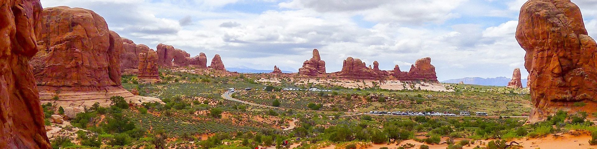
The area around the small town of Moab in Utah really packs a punch when it comes to epic hiking! This otherworldly landscape is like no other, with red sandstone that glows warmly under the hot sun, strange rock formations that tower over the trails, and plunging gorges, created by the incessant flow of the Colorado River. Hiking in Moab and Arches National Park is an experience you’ll never forget.
Moab is bordered by two of Utah’s most incredible national parks: Arches and Canyonlands, both of which boast some of the finest and most dramatic scenery in the United States. The vibrant color of the red sandstone of this region contrasts starkly with the blue sky and green desert vegetation, creating a visual spectacle that will take your breath away. With rocks carved by the elements into dazzling arches and precariously balanced pinnacles, hiking here is a rare delight.
As the name suggests, Arches National Park is known for its fabulous stone arches. The entire park is situated over a salt bed lying in the earth’s rock, created 300 million years ago when the region was part of an inland sea. As this layer was compressed by debris collected over millions of years, the salt bed became fluid, pushing upwards to create huge domes and ridges. With the help of erosion, these domes were eventually shaped into the colossal arches that we see today across the park. This natural phenomenon is truly staggering, and hiking in this landscape is a unique experience that you’ll treasure forever.
Moab is one of Utah’s best-kept secrets, but increasingly, more and more visitors are coming to appreciate the beauty of this wild place, and to take advantage of the opportunity to enjoy some epic outdoor adventures! Get ahead of the trend and start planning your trip today, with our guide to hiking in Moab and Arches National Park.
Types Of Hiking In Moab and Arches National Park
Hiking in Moab and Arches National Park is an ideal activity for families, or for hikers who are looking for easy trails in truly awe-inspiring landscapes. Many of the hikes in Moab and Arches National Park are short, not too steep, and pass along well-maintained paths, so it’s a good option if you’re a beginner hiker. Kids will love gazing upon the strange rock formations and towering arches, and this is a fabulous spot for photos and a leisurely hiking experience.
However, if you’re looking for something a little more strenuous, there are many challenging hikes in Moab, particularly if you decide to combine some of the shorter hikes into a full day trek. However, beware – in the hot summer months the blazing sun can make even easy trails a challenge, so you’ll need to be fit and well prepared to take on a full day hike. If you’re really adventurous, try your hand at trail running – in recent years the popularity of this activity has exploded in Moab, and you’ll find plenty of ways to push your limits and test your fitness.
Easy Hikes In Moab and Arches National Park
Grandstaff Trail Hike: This is a classic Moab trail suitable for hikers of all ages! The path leads through a narrow valley with high cliffs, before arriving at the Morning Glory Bridge. This natural arch spans 75m, and is a perfect spot to take some impressive photos. The trail is shaded and relatively flat for most of the way, making it one of the best easy hikes in Moab and Arches National Park.
Family Hikes In Moab and Arches National Park
Mill Creek Hike: This relatively easy hike follows Mill Creek through a picturesque gorge, passing a number of gushing waterfalls. It’s a wonderful spot for kids, especially older children who will love splashing in the cool waters! There are lots of possibilities to extend the hike by heading further up the valley, or you can simply relax with a picnic next to the tranquil pool that sits next to the final waterfall.
Day Hikes In Moab and Arches National Park
Portal Overlook Hike: This stunning, slightly challenging route is one of the best day hikes in Moab and Arches National Park. You’ll climb up a well-graded path and until you see the Le Sal Mountains come into view, a looming presence over the entire region. Come early in the season to catch a glimpse of these striking hills covered in snow.
Challenging Hikes In Moab and Arches National Park
Fisher Towers Hike: This popular route is one of the most popular challenging hikes in Moab and Arches National Park. The trail ascends slowly but surely to the majestic Fisher Towers, two monumental sandstone towers that make an excellent spot for climbing. You’ll have a panoramic view over this colorful region, taking in the glowing sandstone rocks, the brown Colorado River, and the steep cliffs of the valley.
Best Hikes In Moab and Arches National Park
Dead Horse Loop Point Hike: This fantastic hike offers a tremendous variety of scenery, passing by the ominously named Dead Horse Loop Point. This natural corral was once used as a home for the horses of local cowboys, many of which sadly died of exposure and lack of water. The views from here are unparalleled, with a panorama that extends over the colorful rocks, deep canyons, towering pinnacles, and the Colorado River.
Park Avenue Hike: This short hike is filled with incredible sights, characteristic of the region around Moab! The path runs down a picturesque narrow canyon with views of the sheer sandstone cliffs and desert towers along the way. Make sure to come with plenty of layers, as this narrow gorge acts as a wind tunnel, and it can become very chilly!
Devil’s Garden Hike: This beautiful route through the so-called ‘Devil’s Garden’ is a wonderful way to see some of incredible stone arches that the Moab region is famous for. In particular, don’t miss the stunning Tunnel Arch and Pine Tree Arch, just a short detour from the main trail. The final part of the hike is dominated by the delicate Landscape Arch, a staggering natural wonder that looms large over the trail.
Delicate Arch Hike: This popular route is one of the best hikes in Moab and Arches National Park. Take care on hot days, as the uphill sections are steep and can become a bit of a struggle. The trail climbs steeply, but the rewards are incredible: a perfect view of Delicate Arch, the largest in Arches National Park. Sit in the natural amphitheater underneath the arch, relax and enjoy the view!
Double Arch Hike: As the name suggests, this hike takes you to not one, but two incredible arches in Moab. The trail is easy, straightforward, and not too strenuous, making it perfect for families with young children or anyone looking for an easy hike. This magnificent natural monument was used as a filming location for Indiana Jones and the Last Crusade, so this hike is a must for movie buffs!
Balanced Rock Hike: Moab and Arches National Park are famous for their arches and towering rock pinnacles, and Balanced Rock is one of the most famous natural stone monuments in the park. This looming tower stands 39m high, and is set against a dramatic, otherworldly landscape covered in strange rock formations and steep gorges. This short hike is the best way to experience Balanced Rock, and it’s a wonderful family expedition.
When Is The Best Time To Hike In Moab and Arches National Park?
Moab and Arches National Park is a year-round destination, and it’s possible to visit at almost any time. However, the extremes of desert weather mean that the winters can be very cold, with snow on higher ground, and the summers are extremely hot, hitting temperatures in the high 30s Celsius. As a result, we think that the best time to hike in Moab and Arches National Park is in spring and autumn. September and October are very popular times to visit the park, with perfect temperatures and a number of cultural events, including the Red Rocks Art Festival. However, the trails can be as busy as the peak summer months, so it’s not the best time to visit if you want to avoid the crowds. Comparatively, spring is less crowded, and you’ll enjoy mild temperatures, gorgeous sunsets, and plenty of family-friendly activities such as free guided day walks in Arches National Park. While many visitors overlook the winter months, due to the freezing temperatures and inclement weather, this can be a wonderful time to experience Moab, exploring the strange beauty of this region in peace and solitude.
Other Outdoor Activities In Moab and Arches National Park
This incredible region has emerged as a hub for adventure seekers in recent years, and in addition to hiking you’ll find plenty of other outdoor activities in Moab and Arches National Park! The strange carved rocks that make up this delicate landscape are a real draw for rock climbers, and you’ll find a wide array of routes all around Moab and within Arches National Park. In addition to this, the region has recently become a popular destination for trail running, backpacking, and camping, and it’s a wonderful place to observe the night sky in all its starry brilliance. Finally, if you’re keen to test the waters of the mighty Colorado River, you can always go rafting, canoeing or kayaking.
How To Plan A Trip To Moab and Arches National Park
The region around Moab and Arches National Park is a fabulous place for a hiking trip! If you’re thinking of heading here for some outdoor adventuring, don’t forget to check out our guide to planning a trip to Moab and Arches National Park. If you’re looking for ideas for awesome hikes in this region, we’ve put together a list of the top 10 hikes in Moab and Arches National Park, or look further afield and check out our list of the best hikes in Utah. We’ve got all the information you’ll need, plenty of recommendations on where to visit, stay and eat, and insider tips that will make your trip run smoothly.
Frequently-Asked-Questions About Moab and Arches National Park
How many days do you need in Moab?
The area around Moab is pack full of incredible sights and places to hike, and you could easily spend weeks (or even months!) exploring all the corners of this spectacular region. However, most people visit for 3-5 days. This will allow you to hike in Arches and Canyonlands National Parks, and drive to some of the most popular viewpoints.
What is the closest airport to Moab?
The closest major airport to Moab can be found in Salt Lake City, which is 236 miles, or a four-hour drive from Moab.
Can you visit Arches and Canyonlands National Parks in one day?
Moab is located next to two incredible national parks, Arches and Canyonlands, and during your trip you’ll definitely want to see them both. In the summer, when the days are longer, it’s possible to visit both parks in the same day, with a short hike in each of them. However, we’d recommend that you take a little more time to enjoy all that these two remarkable parks have to offer.
Displaying 40 of 65 routes
Route guides for Hiking in Moab and Arches National Park
0 hours
144 hours
0
5
0
10
Dead Horse Point Hike Route Guide
Portal Overlook Route Guide
Mill Creek Route Guide
Fisher Towers Route Guide
Grandstaff Trail Route Guide
Devils Garden Loop Route Guide
Park Avenue Route Guide
Devil’s Garden Route Guide
Delicate Arch Route Guide
Double Arch Route Guide
Balanced Rock Route Guide
The Corona Arch Trail Route Guide
Landscape Arch Trail Route Guide
Fiery Furnace and Surprise Arch Route Guide
Castleton Tower Trail Route Guide
Windows Loop Trail Route Guide
Wolfe Ranch and Petroglyph Trail Route Guide
Windows Loop to Turret Arch Route Guide
Broken Arch Trail Route Guide
Skyline Arch Trail Route Guide
Navajo Arch Trail Route Guide
The Tunnel Arch and Pine Tree Arch Trail Route Guide
Tunnel Arch Trail Route Guide
Partition Arch Trail Route Guide
Wall Arch and Pine Tree Arch Route Guide
Copper Ridge Dinosaur Tracks Trail Route Guide
Tower Arch Trail Route Guide
Moab Rim Trail Route Guide
Delicate Arch Viewpoint Route Guide
Klondike Bluffs Trail Route Guide
Eye of the Whale Trail Route Guide
Professor Creek and Mary Jane Canyon Trail Route Guide
Dark Angel Trail Route Guide
Private Arch Trail Route Guide
The Gold Knob Trail Route Guide
The StairMaster via Moab Rim Trail Route Guide
The Cove of Caves via Parade of Elephants Trail Route Guide
Cowboy Jacuzzis via Mill Creek Rim Trail Route Guide
Jackson Hole Trail Route Guide
Jeep Arch Route Guide
1-40 of 65 routes
WE ARE HERE TO HELP
Let someone else do the hard work, book a custom tour in over 85 countries.
Chat with us on our contact page or fill out the form below!