Hikes in Zion National Park
Activities in Zion National Park
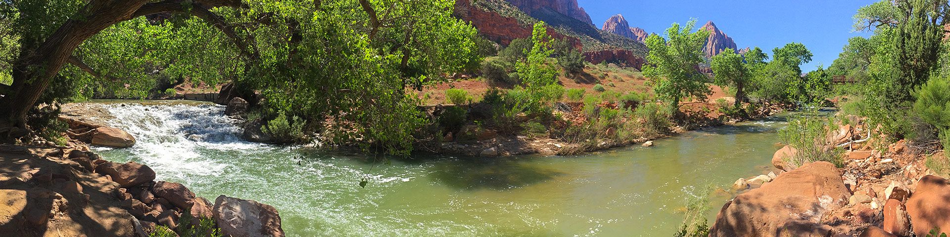
Shaped by the course of the Virgin River, the sandstone rocks of Zion National Park glow red in the bright sunlight, carved over millennia to form strange and otherworldly shapes. This desert oasis, fed by the coursing river, provides a visual spectacle like no other, with deep red rocks, lush green plants, and cool blue waters. Hiking in Zion National Park is an experience you’ll never forget.
Zion National Park is packed with spectacular, accessible trails through some of Utah’s most dramatic landscapes. At the center of the park, the Zion Canyon is the focal point of most hikes, with cliff walls that rise 2,000 m high in places, and narrow to a width of 20 m in others. Hiking here will take you to high overlooks, with a stunning panorama of the park, or deep into the depths of the canyon where you’ll walk through the lush valley bottom or wade through the chilly waters of the river.
Zion’s epic rocks are a major draw for most visitors, and you’ll find some spectacular, gravity-defying rock arches that provide ample photo opportunities. In addition, this part of Utah has a long history of human habitation, with traces of settlement stretching back around 8,000 years. It’s easy to imagine our human ancestors walking through this timeless landscape, admiring the beautiful rocks and lush vegetation.
Zion National Park is Utah’s finest gem, and a spectacular place for a hiking trip. If you’re planning a trip to this remarkable region, we’ve got some tips and trail suggestions that will give you plenty of inspiration. Happy hiking!
Types Of Hiking In Zion National Park
Hiking in Zion National Park is like passing into another world. With deep red rocks, jaw-dropping canyons, and pristine rivers passing through picturesque valleys, this stunning place has hiking trails for just about everyone. To prevent further erosion of the delicate sandstone rocks, many of the trails in Zion National Park are paved, making them particularly accessible if you’re travelling with a buggy or a visitor with mobility issues. Kids will love the strange, alien terrain, and there is an abundance of short, easy trails with lots of things to see along the way.
If, on the other hand, you’re looking for a more challenging adventure, Zion National Park has plenty of thrills in store. Ascending the cables at Angel’s Landing is sure to get your heart thumping (and not only from exertion), with jaw-dropping views and a climb that will pose a good challenge for most hikers. If you need to cool off, wade straight into the narrows, where you’ll hike, waist deep in water, through a tall canyon that looks like it’s come straight out of a movie. The sheer variety of trails here will keep even the most adventurous hikers happy.
Easy Hikes In Zion National Park
Pa’rus River Trail: This short hike over flat terrain is an ideal option for families and one of our favorite easy hikes in Zion National Park! ‘Pa’rus’ comes from the Palute word meaning “bubbling, tumbling water”, and this paved trail along the Virgin River certainly does justice to the name. As you hike through the bottom of the canyon, alongside the gurgling waters of the river, you’ll have a fantastic view of Bridge Mountain and the Beehive.
Family Hikes In Zion National Park
Weeping Wall Hike: This short steep trail will bring you to the secluded Weeping Wall, so named for the trickling waters that drip steadily from the sloping rock face. This is an ideal family hike for warm days, despite the steep ascent, as the entire trail is shaded from the hot sun. The cliffs are clothed in lush vegetation, making this a lovely spot to stay a while and take advantage of the dripping waters.
Day Hikes In Zion National Park
Observation Point Hike: Observation Point is one of the most scenic viewpoints in Zion National Park, towering over the Zion Canyon. The ascent is challenging, passing through a series of switchbacks up onto a small, cool ridge. The views from the summit are remarkable, especially early in the morning when the first rays of sun hit the canyon.
Challenging Hikes In Zion National Park
Angel’s Landing Hike: The hike up to Angel’s Landing is, without doubt, one of the best challenging hikes in Zion National Park. You’ll pass up a series of short, steep switchbacks known as Walter’s Wiggles, before arriving at the ridge of Scout’s Lookout. To get to Angel’s Landing itself you’ll need to negotiate the infamous run of chains before emerging at the summit, where you’ll enjoy a remarkable panorama of the park.
Best Hikes In Zion National Park
Taylor Creek Trail Hike: The Taylor Creek Trail passes through some of the most remarkable scenery in Zion National Park, passing through the red cliff walls of the Kolob Canyon. The striking sandstone features of the gorge can be easily appreciated all the length of this wonderful hike, passing back and forth over the creek on an undulating path. At the end of the route, you’ll reach the impressive Double Arch Alcove, a sandstone amphitheater that is sure to take your breath away.
Canyon Overlook Hike: The short walk to Canyon Overlook is one of our favorites, and arguably one of the best hikes in Zion National Park. This trail will give you jaw-dropping views over both the Zion and Pine Creek Canyons, and is accessed via a rock staircase with a helpful handrail, so all hikers should be happy here. This trail is one of the best ways to experience the majesty of Zion National Park.
Hidden Canyon Hike: The Hidden Canyon hike offers a fantastic alternative for hikers looking for the thrills associated with Angel’s Landing, but who aren’t yet prepared to tackle the vertiginous cables. The latter part of this route is lined with cables to help you ascend the sandstone cliffs, but they are easy to tackle and you’ll be rewarded with a wonderful view of the valley, red cliffs, and Cable Mountain.
The Narrows Hike: Be prepared to get wet feet on this fun hike along the Virgin River! The trail follows the gurgling river as it passes through a picturesque slot canyon. You’ll follow the path for 1.6km before entering the river and wading through the canyon in the water. It’s possible to hire equipment for this popular and iconic hike in nearby Springdale, where you can pick up waders, water boots and hiking poles.
East Rim Trail Hike: This pleasant hike is an easy trail with some killer views, passing through Echo Canyon all the way to Weeping Rock. This is an adaptable and fun hike, as you can customize the length depending on your available time and energy levels. We suggest following the trail all the way to Jolly Gulch Creek, where you’ll find a picturesque waterfall.
Emerald Pools Hike: The hike to Emerald Pools offers spectacular views of the sandstone cliffs that line the Virgin River valley. You’ll ascend up a series of switchbacks with lovely views of the lush oasis, before arriving at the Upper Pools where you can relax in peace as you gaze at the tranquil waters. The Middle and Lower Pools can be accessed on the way back down, by taking one of the many paths that branch off the main trail.
When Is The Best Time To Hike In Zion National Park?
Temperatures in Zion National Park can be somewhat extreme, meaning that you’ll want to time your visit carefully to make sure you have the perfect hiking conditions. The winter months can be very cold, with temperatures dropping below freezing in December and January, whereas summer temperatures can reach the high 30s. The best time to hike in Zion National Park is in autumn, when the weather is clear and cool, there are fewer crowds on the trails, and most routes will be clear. Although spring offers pleasant temperatures, some trails are closed due to the flooding of the Virgin River. Summer is a very popular time for hiking in Zion National Park, but this means that the trails can be very crowded, as millions of people flock to see the fantastic natural treasures of this unique region.
Other Outdoor Activities In Zion National Park
Once you’ve exhausted the hiking trails, there are plenty of other outdoor activities in Zion National Park that will keep you busy! In addition to hiking and backpacking, this unique and beautiful park is the perfect place to go horseback riding. You can relax by the Virgin River and enjoy a little fishing, or even take the opportunity to try your hand at canyoning! If you’re a budding photographer, this is a wonderful destination, with plenty of scope to experiment with the play of the light on the colorful rocks.
How To Plan A Trip To Zion National Park
If the thought of these hikes has given you itchy feet, use our guide to help you plan your trip to Zion National Park! There’s never been a better time to visit this majestic, beautiful place, and to help you make the most of your trip we’ve put together all the information you’ll need to get started. From insider tips on where to stay and where to eat, to all our favorites hikes, we’ve got everything required to plan your bucket list adventures. Some of these trails in Zion National Park are considered to be the best hikes in Utah, and we think you’ll love them just as much as we do!
Frequently-Asked-Questions About Zion National Park
What is the most dangerous hike in Zion?
The hike up Angel’s Landing is one of the most iconic hikes in Zion National Park, involving a steep climb up a series of switchbacks and a thrilling ascent via cables. This is a challenging route, and it’s important to take great care on the cables, as there is a sheer drop, which has given it a reputation as the most dangerous hike in the park. There have been 8 fatalities on the route since 2004, but the overwhelming majority of people make the ascent without any problems.
How many hiking trails are in Zion National Park?
There are 46 hiking trails in Zion National Park, ranging from short, easy treks, to challenging ascents and long canyon hikes.
Can you go mountain biking in Zion National Park?
Mountain biking is not permitted in Zion National Park. The only trail that is suitable for bikes is the Pa’rus Trail.
How much time will you need in Zion?
Many of the trails in Zion National Park are short and accessible, meaning that if you’re short on time, you can still explore many of the riches that this wonderful park has to offer. We’d recommend spending at least 2-3 days here, so you can make the most of the glorious sunsets and sunrises, and fit in a couple of good hikes. If you have more time, there is plenty to explore, and you can easily fill 5-7 days will epic hikes and adventures across the park.
Displaying 40 of 55 routes
Route guides for Hiking in Zion National Park
0 hours
144 hours
0
5
0
10
Observation Point Trail Route Guide
Angel’s Landing Route Guide
Taylor Creek Trail Route Guide
Pa’rus River Trail Route Guide
Canyon Overlook Route Guide
Hidden Canyon Trail Route Guide
The Narrows Hike Route Guide
East Rim Trail Route Guide
Emerald Pools Route Guide
Weeping Rock Hike Route Guide
Zion Narrows: Bottom up to Big Springs Route Guide
The Narrows: Top-Down Route Guide
The Zion Narrows Riverside Walk Route Guide
The Subway Trail Route Guide
The Watchman Trail Route Guide
La Verkin Creek Trail to Kolob Arch Route Guide
Observation Point via The East Mesa Trail Route Guide
The West Rim Trail (Top Down) Route Guide
Lower Emerald Pool Trail Route Guide
Middle Fork of Taylor Creek Trail Route Guide
Scout Lookout via West Rim Trail Route Guide
Hop Valley and Kolob Arch Trail Route Guide
Checkerboard Mesa Canyon Trail Route Guide
Lava Point Overlook Trail Route Guide
Kayenta Trail to the Emerald Pools Route Guide
Zion Grotto Trail Route Guide
Timber Creek Overlook Trail Route Guide
The East Mesa Trail Route Guide
Lower Pine Creek Waterfall Trail Route Guide
The Many Pools Trail Route Guide
Angels Landing, West Rim, Telephone Loop Route Guide
Cable Mountain vis Stave Spring Route Guide
Wildcat Canyon Trail Route Guide
Cockeye Falls Trail Route Guide
West Bank of the Virgin River Hike Route Guide
Petroglyph Pools Trail Route Guide
The Lower Clear Creek Trail Route Guide
Deertrap Mountain Trail Route Guide
Wildcat Valley Trail Route Guide
North Fork of Taylor Creek Trail Route Guide
1-40 of 55 routes
WE ARE HERE TO HELP
Let someone else do the hard work, book a custom tour in over 85 countries.
Chat with us on our contact page or fill out the form below!