
BlogDestinationsCanada’s Great Divide Trail – A Full Guide and Itinerary
Canada’s Great Divide Trail – A Full Guide and Itinerary
Richard Campbell
Apr 28, 2020
Richard is the Founder of 10Adventures, and as a writer shares his experience from 30+ years exploring the world by foot, bike, ski, and boat.
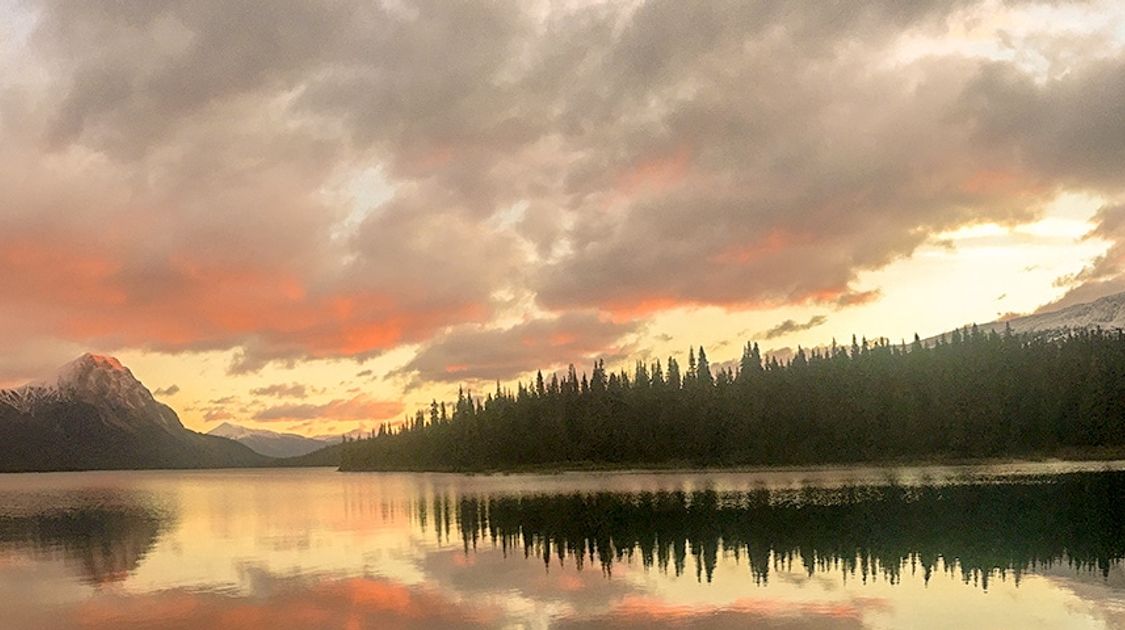
The Great Divide Trail is Canada’s iconic long-distance backpacking adventure. It follows the Great Divide in the Rocky Mountains, weaving between Alberta and British Columbia for over 1,100km and crossing some of the most scenic parks in Canada. Backpackers will enjoy the beautiful scenery, many glaciers, jagged rocky peaks, wildflowers, wildlife, and so much more.
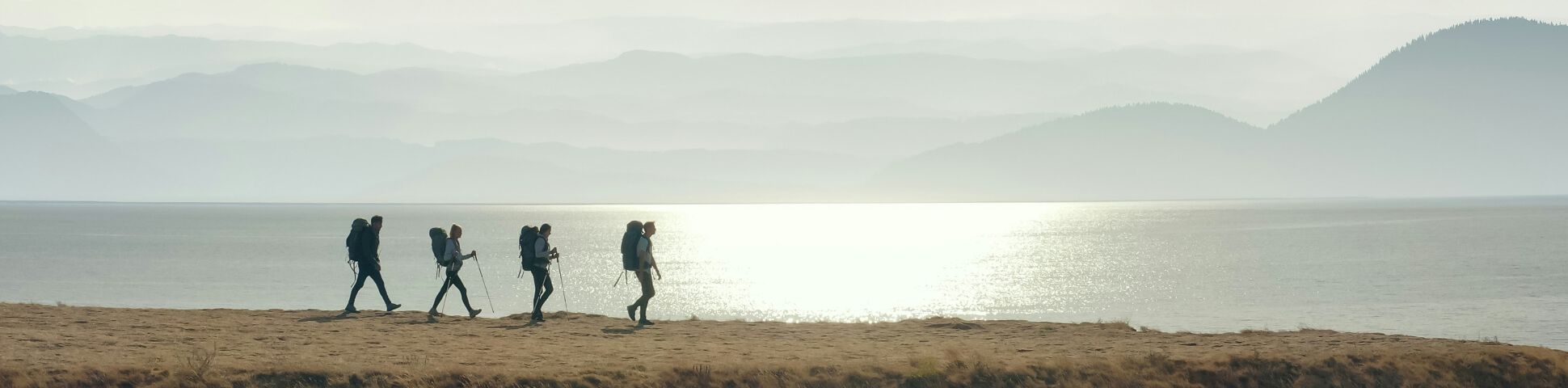
While this trail offers tremendous views, it should not be taken lightly. Like any through-hike, the Great Divide Trail requires careful planning and navigation skills. The distances covered each day depend on personal preference, but some days can have over 30km and 1,000m in elevation gain. Through-hikers typically take around 8 weeks to complete the traverse.
This trek is a unique way to enjoy pure mountain wilderness away from the crowds and visit several parks that are on many hikers’ bucket list.
The Basics of the Great Divide Trail
One of the challenges of through-hiking the Great Divide Trail (or GDT) is the planning. As it goes through five national parks and nine provincial parks, day-use passes are required for the national parks and camping fees apply for some campgrounds along the way. Typically, purchasing an annual pass for national parks is the most cost-effective option.
Planning provisions is another logistic element to consider. Some stretches as long as 200km are in the backcountry and offer no option for resupplying. There are stores in towns crossed – or reached by a short detour – and most will accept major credit cards or Canadian cash. Some campgrounds that charge a fee may only accept cash. As this trail is in Western Canada, English is spoken in all towns and villages along the way.
Finally, the Great Divide Trail is not as famous as its sister long-distance trails in the United States. For that reason, it is much less travelled and not always signed. About 90% of it is on trails or tracks, while the rest is on wilderness routes. Anyone attempting the GDT should have experience in bushwhacking and navigation, as well as be ready for snow, rain, and fording rivers.
This trek is both challenging and rewarding, and that is why we love it. Fewer people attempt it due to the logistics and planning required, so trekkers enjoy a true and quiet through-hiking experience, something that is lost with the famous American long-distance trails. The landscape is simply stunning and there are plenty of opportunities to spot wildlife along the way, including mountain goats, moose, wolves, and bears. The GDT offers a fantastic immersion in the wilderness and a way to truly connect with nature.
When to Go on the Great Divide Trail
The Great Divide Trail should be attempted between late June and mid-September. During that period, all park and town services will be open. Most sections will also be snow-free and the rivers should be quieter. Besides, several sections of the GDT are closed in winter and navigation would be a serious challenge with the snow.
Some years have had less snow, which means it might be possible to hike snow-free in early June or until the end of September. Trekkers should not count on that, however. Aiming for the late June to mid-September window is the safest option. It’s important to be prepared for cold temperatures and precipitation as well. It typically snows in the Canadian Rockies every month of the year, and there are regularly snowstorms in late-August and early September.
As the GDT goes up to 2,590m and snowfall in July and August is a possibility, you should also carry a GPS device and maps, to help you find your way if you wake up to the trail covered in snow. Do not rely on solely a GPS device; paper maps never fail. There’s no cellphone service in the mountains, so you will need to get weather information in towns and park information locations to assist you in planning.

Miette Pass

Cataract Pass
Bugs on the Great Divide Trail
Flies and mosquitos should not be an issue early in the season, but they might be one later on. Bringing a bug net for the head can be a good idea. Summer is also bear season as they come out to feast on berries and insects.
Bears on the Great Divide Trail
Finally, this route goes in wild terrain, and a bear encounter is possible. Knowing how to store your food, travel in bear terrain, and what to do if you encounter a bear is critical. Also, park officials strongly recommend bear spray.
Great Divide Trail Accommodation
Anyone tackling this trek must enjoy backcountry camping. There are about a dozen opportunities to spend the night under a hard roof, some of which are in primitive shelters or a bit off route. All other nights will be spent in the tent, mostly in developed and undeveloped backcountry sites. Most camping sites have water either at the site or nearby. Most sites allow fires, but fire bans may apply later in the summer if the weather has been dry.
Reservations at some campgrounds are required. There are many ways to plan the trek and campgrounds with a fee can be avoided if they are all booked or if there are budget constraints. Staying at hotels with hot showers is also possible in seven places. The GDT crosses few towns, however, so trekkers will have sparse access to services such as Wi-Fi, laundromats, showers, and shops. Some towns also require a short detour, usually around 2-3km round-trip.
Food on the Great Divide Trail
The trail’s remoteness and pristine wilderness are what makes this trail so great. It also means it has little human activity. A few towns along the way have restaurants and pubs that serve hot meals. They also have stores or markets, but some only sell the basics and others are off route. That means trail meals and snacks will make up most of the trekkers’ diet on the GDT.
Food will also be an important part of planning. Packages can be sent to drop points to allow for re-supply. It is greatly recommended that food packages be sealed tightly as some resilient mice may attempt to chew through boxes to get to your food. Otherwise, food supplies can be purchased in some towns along the way. However, choosing that option can mean sometimes carrying a heavier backpack or having to depend on store opening hours. Finally, stores may not carry the preferred food items, so this could greatly impact the diet.
Trekking with a lot of food poses another minor challenge: storage at night. Animals may be attracted by the smell of food, so protecting it is important. A designated cooking spot should be established at least 100m away from the tent in a downwind location. After dinner, food should be stored high in a tree or in a bear canister, away from camp.

Floe Lake from just below Numa Pass

View from Haig Glacier with Lawson Lake on the left
GDT Route Information
The GDT’s southern terminus is Waterton Lakes National Park in Alberta, right where the US’ Continental Divide Trail ends. Its northern terminus is 1,100km away, in Kakwa Lake Provincial Park in British Columbia. It goes through some of the most beautiful national parks of Canada: Banff, Kootenay, Yoho, and Jasper.
The greatest challenge the GDT may pose is route-finding. As no official body recognizes the GDT, it is not marked like some other long trails, particularly the popular ones in Europe. It also requires more planning for food and implies a lot of backcountry camping, often with few or no people around. For those reasons, it sees much less traffic and requires good navigation skills.
Trekkers must do their research before starting this beautiful adventure. They should carry a map and compass, and know how to use them. A GPS device with downloaded maps or even a tracklog is also a very useful tool. About 90% of the route is on established trails or tracks, but there are no signs marking the GDT. Signage encountered along the way will only be for local trails. This challenge only makes the trek more interesting and completing it more rewarding!
The route goes through forests, meadows, passes, mountains, rivers, and a variety of other natural features. It is extremely varied and geographically significant. The common denominators are the Rocky Mountains and the Great Divide, which separates the water that flows into the Pacific Ocean from the water that flows into Hudson Bay.
Great Divide Trail Map
Great Divide Trail Itinerary
This trail takes you into the breath-taking wilderness of the Canadian Rockies. Hiking it implies an experience of freedom and connection with nature. For that reason, there are no fixed rules or itinerary for completing it. Some people do it in one summer while others choose to section-hike it. That means they only complete one section and then return another year to complete another section until they have hiked it from start to finish.
We have broken down the trail by section to give you an idea of what your itinerary could look like. This can be adapted based on the campsites available.
SECTION A: US Border to Coleman
- Number of days: 8
- Distance: approximately 153 km
- Elevation gain: approximately 5,600 m
This first section of the Great Divide Trail is said to be one of the most scenic, but all other long sections are very scenic as well. It features nice ridge walks with views of valleys and snowy mountains to the west and the prairies to the east. This section was closed in 2018 due to the forest fires.
SECTION B: Coleman to Peter Lougheed Visitor Centre
- Number of days: 8
- Distance: approximately 197 km
- Elevation gain: approximately 5,750 m
The hiking in this section is on a mix of trails and ATV roads. It also requires a little bushwhacking and fording a few streams, but this should be a formality in dry years. Some of the highlights of this section include hiking on ridges and along rivers and creeks, stunning mountain lakes and great views of the divide, High Rock Range, and Beehive Mountain

Ascent to Tornado Pass

David Thompson Heritage Trail
SECTION C: Peter Lougheed (Kananaskis) to Egypt Lake (official end: Field)
- Number of days: 7
- Distance: approximately 132 km
- Elevation gain: approximately 3,500 m
The Kananaskis region is famous for its views and you will enjoy them on this section. Most days feature excellent views of the surrounding mountains and visits to lakes. This section goes through beautiful Banff National Park and its famous alpine scenery and meadows.
SECTION D: Field to Saskatchewan Crossing
- Number of days: 4
- Distance: approximately 96 km
- Elevation gain: approximately 1,700 m
This short section is on a mix of trails and forest service roads. It still offers nice views, however, and crosses several creeks. The starting point of the section is in Yoho National Park, close to the impressive Natural Bridge, which is well worth a visit.
SECTION E: Saskatchewan Crossing to Jasper
- Number of days: 6
- Distance: approximately 174 km
- Elevation gain: approximately 5,300 m
Here, you will enter Jasper National Park and as would be expected, it is eye candy. You will see canyons, cross over passes, and walk on open ridges. The highlights are Owen Pass, Michelle Pass, Pinto Pass, Jonas Shoulder, Maligne Pass, and Big Shovel Pass. This is what the Canadian Rockies are all about!

Jonas Shoulder

On the top of Big Shale Hill
SECTION F: Jasper to Mount Robson
- Number of days: 4
- Distance: approximately 129 km
- Elevation gain: approximately 3,500 m
Don’t let the low number of days fool you! This short section is challenging. It requires route-finding skills and has a few tricky fords. You will be rewarded with your first views of Mount Robson, the highest point of the Canadian Rockies.
SECTION G: Mount Robson to Kakwa Lake
- Number of days: 9
- Distance: approximately 228 km
- Elevation gain: approximately 6,900 m
The GDT is coming to an end. This is the longest and wildest section. It takes you from Mount Robson Provincial Park to Kakwa Lake Provincial Park. It provides a good recap of the journey thus far as the views continue to be excellent. There are numerous lakes and creeks – some requiring fording – and some bushwhacking. Jackpine Pass and Fetherstonhaugh Pass are highlights of this section and jewels of this trek.
Note that from the Kakwa Lake Trailhead, you are still a long way from civilization. If you have not arranged a ride, you will need to hike out for 75 km on a forest road. Odds of hitching a ride are better on day two.
Our Favourite GDT Route
Like any through-hike, there are two possible directions. The GDT is typically completed from south to north. The reason is simple: snow. The south will be snow-free earlier in the summer. Starting at the southern terminus will also leave more time for the snow to melt in the high and snowier passes of the northern sections. Trekkers can start from the north, but it is recommended that they start a few weeks later in the summer to allow for the snow to melt.
Starting from the south early in the summer is the best bet to avoid flies as much as possible. It also allows taking advantage of the longest days of summer. As trekkers make their way north, they will keep enjoying long hours of sunlight due to the greater latitude.
There are several options about where to finish the GDT. While the official way is to hike to Kakwa Lake in Kakwa Provincial Park, most trekkers choose to end their journey at Mount Robson. This 32km side-trip leads to a classic spot of the Rockies and this touristic area may be a good bet to catch a ride back home. Continuing to Kakwa Lake adds about 200km of hiking to a remote area where catching a ride back south can be a problem if not previously arranged.
There are various side-trips to choose from to lengthen the trek or get to different viewpoints. There are too many to cover in this article, but as this trek follows the Great Divide, most options imply ascending to ridges and following them as the normal route stays lower. Barnaby Ridge and Wonder Pass are classic side trips that will reward hikers with amazing views while also helping avoid brushy sections.
One last interesting detour of note is to climb Nub Peak in Mount Assiniboine Provincial Park. At 2,746m, this mountain does not require much effort and the views of Lake Magog and Mount Assiniboine – the Matterhorn of North America – are some of the best of the trek.
After the Trek
The right way to end a through-hike like this one is to get a hot shower and celebrate! The only problem is that the GDT ends in remote Mount Robson Provincial Park or even more remote Kakwa Lake Provincial Park. Drive or get a ride to a village nearby where showers and warm meals are available. Sit down and think back on your fantastic journey. Memories and scenery like the ones that come with the GDT are truly unique.
The best way to enjoy the Canadian Rocky Mountains is deep and total immersion in this stunning wilderness that only a few places on Earth can rival.

Emperor Falls on the Berg Lake Trail

snow tipped mountains
Frequently Asked Questions About the Great Divide Trail
How long does it take to hike the Great Divide Trail?
The Great Divide Trail takes around 45-56 days to complete. The length depends on your itinerary, pace, and trail conditions.
Where is the Great Divide Trail?
The GDT is in the Canadian Rockies, stretching through the Continental Divide between Alberta and British Columbia.
How long is the Great Divide Trail?
The Great Divide Trail is over 1,100km long.
Do I need a permit to hike the Great Divide Trail?
Yes, as you would have to stay in designated campgrounds in the National and Provincial Parks you will pass, so it is recommended that you arrange for all park entry permits and campsite reservations in advance. National Park Backcountry Permits are also required for any overnight stays in the backcountry of the national parks.
Is it easy to find the trail signage?
No, as only parts of sections A and B are well-marked. The GDT is not officially signed and consists of many separate tracks, wilderness trails, and roads.
Do I need to do it all at once?
No. in fact, there are growing numbers of GDT hikers that do a section or two a year. This allows most regular people to hike this incredible trail over three to six summers.
If you liked this article, you can also check out the best long-distance hikes in the United States.
Richard Campbell
Apr 28, 2020
Richard is the Founder of 10Adventures, and as a writer shares his experience from 30+ years exploring the world by foot, bike, ski, and boat.
Recent stories
General
Travel Styles at 10Adventures: Find the Adventure That Fits You
10Adventures specializes in curated active holidays for travellers who want a trip shaped around their interests, ability, pace, and preferred dates.
Richard Campbell
Jul 26, 2026
Destinations
Japan Cycling Tours: Best Bike Routes and Trips for 2026
Japan cycling tours beautifully intertwine scenic landscapes with vibrant culture and signature dishes.
Nadine Gravis
Jul 25, 2026
Destinations
Europe’s Best Spring Walking Tours for the Over-50 Traveller
Spring is the season of renewal; wildflowers burst into color, coastal breezes soften, and historic villages wake after the quiet of winter.
Alex Todd
Jul 25, 2026