
BlogDestinationsGreenland’s Arctic Circle Trail
Greenland’s Arctic Circle Trail

Lisa Germany
Apr 8, 2019
Lisa is a travel writer and photographer who originally comes from a small town in Australia. She quit her full-time job in 2016 (she was previously a professional Astronomer and then an eLearning/Learning Spaces expert for Universities) and has been travelling the world ever since.
Greenland’s most famous hike, the Arctic Circle Trail, stretches for 160.0 km along one of the longest sections of ice-free land on the world’s largest island. Typically done over 9 days (as suggested by the locations of the huts), this remote hike takes you through rolling arctic tundra, which steadily becomes more dramatic as you approach the coast. This is one of the few trails of the world where you can hike for over a week and have no contact with civilisation. And despite the fame of the Arctic Circle Trail, even at the peak of the hiking season, you will likely not see another person for most of the day.
The Basics

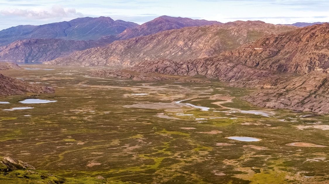
Hiking along Kangerlussuaq Tulleq Fjord on Greenland’s Arctic circle trail

Start of Greenland’s Arctic circle trail near Russell Glacier
Closest Major City: Kangerlussuaq. Note that although Kangerlussuaq is Greenland’s international airport, the town is tiny. Only 500 people live there, most of which service the airport or tourism, so do not expect to arrive and be able to purchase everything you need for the hike. You will be able to get gas and basic food supplies, but not much more than this. You can get direct flights to Kangerlussuaq from Copenhagen.
Start: Kangerlussuaq. You can do this hike in reverse - from Sisimiut to Kangerlussuaq - but I recommend hiking “from the Icesheet to the Ocean”.
End: Sisimiut. You can fly back to Kangerlussuaq and then Copenhagen, or better yet explore Greenland a bit more.
Accommodations: Camping. There are 9 basic backcountry huts on the Arctic Circle Trail, but most are very small (they sleep less than 6 people) and may be full when you arrive. You must bring your own tent.
Costs: There are no costs associated with the trail, nor for the use of the huts.
Length: 9-12 Days, depending on where you start/finish.
When to Go: mid-June through mid-September. If you want relatively pleasant temperatures and to avoid the worst of the Greenland mosquitoes, your best bet is to aim for August.
Best resource on the internet: Visit the official Arctic Circle Trail website.
This is a very remote trek where there is literally nothing but wilderness and a few backcountry huts along the way. It is not a technically difficult hike and it is quite well marked. However, given its extreme remoteness you should only consider it if you already have multi-day hiking experience and appropriate equipment. There is no cell phone signal and nowhere to buy anything once you leave the start point, so you must be fully self-sufficient for the duration of your trek and prepared for changeable and sometimes extreme Arctic weather.
Health

Kangerlussuaq Tulleq Syd hut on Greenland’s Arctic circle trail

Wilderness along Greenland’s Arctic circle trail
If you are fit and healthy and carrying appropriate equipment, there is little to worry about from a health perspective along the Arctic Circle Trail. However, a few things to note:
Water in Greenland is reported to be safe to drink, even directly out of streams and lakes. So although you may be carrying more than a week of food plus all your camping gear, you only need to hike with a 1L water bottle. You can purify if you like, but most people find that there is no need.
Although the Greenlandic mosquitoes are insanely annoying and their bites can be very itchy, they do not carry any diseases. Even if you think you are going to miss the worst of the mosquito season, I recommend bringing a head net and insect repellent with you to save your sanity in case they find you.
One of the most important things to be prepared for along the trail is the changeable arctic weather. Although the days can be relatively warm (up to 15 degrees Celsius), nights are generally quite cool and it has been known to snow during the height of Summer! Make sure you pack a base layer, mid layer, and a wind and waterproof layer at least, even though this is a Summer hike. You will also likely need more than a Summer-weight sleeping bag if you want to sleep well.
Think very carefully about what will happen if you require emergency medical assistance in the middle of the hike. There is no cell phone coverage, so realistically the only way to let the outside world know you need help is with a personal emergency beacon. Make sure you are carrying one! Also make sure that your travel insurance includes helicopter evacuations, as there is no other way to reach you while you are on the trail.
The Route

Vast wilderness on Greenland’s Arctic circle trail

Drinkable water on Greenland’s Arctic circle trail
The trail starts at Kangerlussuaq and, after the first 16.0 km along a dirt road, stone cairns painted with red half-suns (a nod to the Greenlandic flag) lead you off across the arctic tundra.
For the first few days, the scenery is largely rolling hills and an uncountable number of lakes and mountain tarns. The hills gradually become more dramatic as you head towards the coast - a function of the retreat of the glaciers and the greater amount of time the weather has had to erode the landscape.
Ground-hugging bushes including wild blueberries and crowberries (feel free to pick them if they are in season to add to your meals!) line the trail, as do a surprising number of beautiful Greenlandic wildflowers. And you should keep an eye out for Tuttu (reindeer), Umimmak (musk ox), Ukaleq (arctic hare) and Terianniaq (arctic fox) as you go.
Accommodation

Challenging eating with a head net on Greenland’s Arctic circle trail

Typical cairn on Greenland’s Arctic circle trail
Although there are 9 basic backcountry huts spaced along the route from Kangerlussuaq to Sisimiut, you must bring your own tent and everything you need to camp. Most of these huts are very small with space for a maximum of 6 people (in a pinch!). The exceptions are the Canoe Centre (the largest on the trail), the Lake House, and Kangerlusarsuk Tulleq Nord.
Part of the joy and adventure of the Arctic Circle Trail is the fact that you are truly in the middle of nowhere and you can camp wherever you like (you can free camp anywhere in Greenland). If you want to maintain your sense of solitude and avoid other hikers, plan your sections to arrive at the huts around midday and free camp during the evening. Be sure to study the map carefully to choose an appropriate campsite. There are several parts of the trail that are very boggy and the next good campsite may be a lot further than you expect.
Food

One of many lakes along Greenland’s Arctic circle trail

Clear route on Greenland’s Arctic circle trail
You must bring all the food and gas for the duration of your hike with you on the trail. There are no little kiosks along the way where you can top up your supplies. What you start out with must last until you reach the end point.
Think carefully about what you will eat and ensure your meals pack down small and are calorie dense for their weight. I also recommend bringing food for at least one extra day on the trail, as you never know what might happen given the arctic weather in particular.
Proposed Itinerary

Dramatic scenery on Greenland’s Arctic circle trail

Canoe on shore of the lake Amitsorsuaq on Greenland’s Arctic circle trail
Day 000 (optional): Transfer to Point 660 at the Greenland Icesheet
Day 00 (optional): Hike to Russell Glacier 12.0 km.
Day 0 (optional): Hike to Kangerlussuaq 25.0 km
Day 1: Kangerlussuaq to Hundsø 20.0 km
Day 2: Hundsø to Katiffik 20.0 km
Day 3: Katiffik to Kangerluatsiarsuaq (the Canoe Centre) 20.0 km
Day 4: Kangerluatsiarsuaq to Ikkattooq 22.0 km
Day 5: Ikkattooq to Eqalugaarniarfik 11.0 km
Day 6: Eqalugaarniarfik to Innajuattoq II (the Lake House) 19.0 km
Day 7: Innajuattoq II to Nerumaq 16.0 km
Day 8: Nerumaq to Kangerlusarsuk Tulleq Syd or Kangerlusarsuk Tulleq Nord 16.0 km/17.0 km
Day 9: Kangerlusarsuk Tulleq Syd or Kangerlusarsuk Tulleq Nord to Sisimiut 20.0 km/22.0 km
Route Options

Nasaasaaq mountain summit on Greenland’s Arctic circle trail

Wild camping on day 5 on Greenland’s Arctic circle trail
Route options:
- You can skip most of Day 1 (the part along the road) by arranging a transfer from Kangerlussuaq to Kellyville and hiking all the way through to Katiffik as your first day. This is what I did.
- See if you can spy one of the canoes between Katiffik and Kangerluatsiarsuaq. Despite massive duct-tape patches on the hulls, they are surprisingly watertight and offer a nice change from hiking along Lake Amitsorsuaq - the longest lake on the trail
- Day 5 is a short day and most of us chose to keep walking and wild camp on the shores of the lake at the 18.0 km mark (GPS coords: 67.015785 -53.000401).
- To reach the Kangerlusarsuk Tulleq Nord hut, you need to leave the trail and head down to the head of the fjord. I highly recommend this option.
- Innajuattoq II (the Lake House) and Kangerlusarsuk Tulleq Nord are the some of the largest and most beautiful huts on the trail. Note: Kangerlusarsuk Tulleq Nord is not actually on the trail itself
- An amazing route option is to spend an extra night at the end on Nasaasaaq mountain, just outside of Sisimiut. From the Kangerlusarsuk Tulleq huts, follow the Arctic Circle Trail and keep an eye out for a cairn painted with both blue and red markings (GPS coords: 66.93734 -53.559746) and a trail leading up the mountains to your left. Wild camp at the saddle point and (if heights and a bit of rope work doesn’t worry you) climb the summit for a spectacular view over Sisimiut and the surrounding area. If you are not up for a technical ascent, head out to the rocky bluff at the western end of the ridge for a similar but not quite 360 degree view.
GPS positions for Huts in the Article

Lakehouse on Greenland’s Arctic circle trail

Wild blueberries on Greenland’s Arctic circle trail
Hundesø | 66.997421 | -51.014483 |
Katiffik | 66.920334 | -51.360867 |
Canoe Center | 66.921463 | -51.747997 |
Ikkattooq | 66.971863 | -52.170223 |
Eqalugaarniarfik | 66.995605 | -52.356991 |
Innajuattoq II (The Lake House) | 67.056519 | -52.628017 |
Nerumaq | 67.005844 | -52.965691 |
Kangerlusarsuk Tulleq Nord | 66.9879 | -53.205986 |
Kangerluarsuk Tulleq Syd | 66.98024 | -53.251228 |
Written by: Lisa Germany - you can read Lisa’s extensive trip report on the Arctic Circle Trail. She also wrote the official Arctic Circle Trail website.
Lisa Germany
Apr 8, 2019
Lisa is a travel writer and photographer who originally comes from a small town in Australia. She quit her full-time job in 2016 (she was previously a professional Astronomer and then an eLearning/Learning Spaces expert for Universities) and has been travelling the world ever since.
Recent stories
Destinations
Netherlands Bike Trips: Best Cycling Routes and Tours for 2026
Netherlands bike trips are among the easiest and most enjoyable cycling holidays in Europe.
Lynn Campbell
Jul 7, 2026
Destinations
Chile Biking Tours: Best Cycling Routes and Trips for 2026
Chile biking tours are some of the most dramatic cycling experiences in South America.
Nadine Gravis
Jul 7, 2026
General
Booking with 10Adventures: How It Works and What to Expect
Life is stressful enough.
Richard Campbell
Jul 6, 2026