
BlogDestinationsThe Walker’s Haute Route from Chamonix to Zermatt in 2026
The Walker’s Haute Route from Chamonix to Zermatt in 2026
Table of contents

Richard Campbell
Jun 3, 2026
Richard is the Founder of 10Adventures, and as a writer shares his experience from 30+ years exploring the world by foot, bike, ski, and boat.
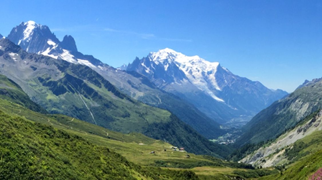
The Walker's Haute Route from Chamonix to Zermatt is one of the world’s classic treks, and 2026 will be a spectacular year to tackle this epic trek. This challenging 200km adventure begins in the alpine mecca of Chamonix, France and traverses wild mountains and small valleys towards Zermatt, Switzerland. En route, the hike crosses some of the most beautiful terrain in the Alps, culminating in the stunning Matterhorn, which rises up above Zermatt.
While the Tour du Mont Blanc is more widely known, and is a stunning walk, those who have walked the TMB and the Haute Route tend to favour the Haute Route as less crowded and more beautiful. If you want to learn more about the TMB then read this Guide to the Tour du Mont Blanc. Here is a link to self-guided Tour du Mont Blanc tours.
With difficult climbs, fantastic views and delicious food, the Haute Route from Chamonix to Zermatt really has it all! It should be noted that the Haute Route is physically strenuous, so anyone planning on completing the trek should be in good physical condition and be comfortable with long days on the trail. Though difficult, this trek sees a lot fewer people than most of the great treks in the Alps - especially when compared with the Tour de Mont Blanc.


What to Expect on the Walker’s Haute Route in 2026
Planning your Walker’s Haute Route trek for 2026? Here is what to know before you book:
- Season: the route opens mid-June and closes by mid-October. Mid-July to mid-September gives the most reliable conditions across all high passes; snow can linger on some passes into early July.
- Book accommodation early: mountain hut beds and hotel rooms along the route fill fast for July and August. Book your self-guided tour or accommodation at least three to six months ahead for peak season dates.
- Tour options: both self-guided and guided tours are available for the full 213 km route and the shorter 7-day Highlights version. Self-guided packages include GPS tracks, pre-booked accommodation, luggage transfers between hotels, and phone support.
- Route conditions: all major passes and alternate routes are operational for the 2026 season. No significant trail or infrastructure changes have been announced. The Matterhall Trail and other valley alternates remain available.
- Budget: the majority of the route passes through Switzerland, one of the most expensive countries in Europe. Budget for Swiss franc prices on food, accommodation and transport. A realistic total budget for the full trek ranges from 560 to 2,250 CHF depending on accommodation choices.
The Basics of the Walker's Haute Route to Zermatt

Refuge Col de Balme on the Walkers Haute Route from Chamonix to Zermatt

Sunset beyond Verbier on the Walkers Haute Route from Chamonix to Zermatt
-
Closest Major City: Geneva, Switzerland
- Start: Chamonix
- Accommodations: Hotel and Refuges
- Costs: $750-$3,000 Per Person (if you want reservations and luggage transfer)
- Length: 12-15 Days
- When to Go: Mid-June through September
- Possible Walking Tours: This is a self-guided Chamonix to Zermatt Trek. For those that want to break the Haute Route into two one-week sections, then this tour is the self-guided first half of the Haute Route, while this is the self-guided second half of the Haute Route.
Distance and Duration of the Walker’s Haute Route
Here is a quick reference for distance, daily stages and typical completion times:
- Total distance: 213 km on the main route from Chamonix to Zermatt. Taking public transport on certain stages or opting for alternate routes will reduce the total.
- Typical duration: 10 to 12 days at a comfortable pace. Fast trekkers can complete the full route in 8 to 9 days; a relaxed itinerary runs 13 to 15 days. The self-guided Highlights tour (Swiss section only) can be completed in 7 days.
- Daily distance: most stages cover 15 to 18 km with 700 to 1,000 m of elevation gain. Some stages are shorter with gondola or public transport options available.
- Alternate routes: there are alternate routes across almost every stage. The Matterhall Trail between St Niklaus and Zermatt, for example, follows the valley floor and can cut your itinerary by a day.
- What affects your total: accommodation availability, weather rest days, transport shortcuts and route diversions all affect overall trek time. Budget one or two extra days as a buffer.
Getting to the Starting Point

Snow between Cabane Mont Fort and Cabane Prafleuri on the Walkers Haute Route from Chamonix to Zermatt

Icy Lake between Mont Fort and Cabane Prafleuri on the Walker's Haute Route from Chamonix to Zermatt
To get to the starting point for the Walker's Haute route in Chamonix, you can fly into Geneva International Airport from any number of airports. From here you can rent a car or take a bus Chamonix, where we recommend getting a hotel in the old town. We love Chamonix, and there is great hiking nearby and it is worth spending a couple of days in Chamonix if you have the time.
You can start the trek in Chamonix, but many trekkers take a bus across the flat valley bottom to the Col De Balme, skipping a flat walk along the valley bottom.
The Chamonix to Zermatt Haute Route
Starting at the base of the Col De Balme, the entire Haute Route follows a remarkably similar pattern. Every day you will wake up, hike up through the trees to a high alpine pass, perhaps wander along a ridge for a while, marvel at the views, then finally descend to an isolated village or mountain hut. Most days are between six and eight hours of walking, with significant elevation gain (two days have over 1,500 m vertical). The untarnished views of pristine mountain peaks, hanging glaciers and expansive valleys, however, are well worth the muscular strain.
The condition of the trail can at times be challenging. Mild scrambling is sometimes necessary, as the grade of the trail can be extremely steep. Route finding can also be difficult, but the Swiss government has put out a very high quality GPS map that you can download for free onto your phone. This tool is extremely useful, and makes any slight anxiety you might have about the route instantly vanish!

View of Arolla from the Walkers Haute Route from Chamonix to Zermatt
The first two legs of the Walker's Haute Route are shared with the Tour de Mont Blanc, so expect to be saying Hello, Bonjour and Ciao a lot since you will be hiking against the flow of most people hiking that trek. Though many people stay in Trient the first night, we highly recommend that you continue along towards Col de Forclaz. There is an old inn here, which though rustic, has incredibly delicious food, and a fantastic atmosphere.
Past the Col de Forclaz there is one crux pass that can be impassable due to snow or storms. Fenetre de l’Arpette is a high mountain pass which funnels storms and high winds. At certain times of the year it can require crampons to ascend. Don’t worry, though, as there is another route one can take to get around it. In fact, every single time the 10adventures crew has completed this trek, we have for some reason or another not been able to ascend the pass! In early and late-season we always ask inn-keepers about the next-days route, and at times have to use our maps to find a detour.

Trient on the Walkers Haute Route from Chamonix to Zermatt

Hiking near Arolla on the Walkers Haute Route from Chamonix to Zermatt
Several sections of the trail simply span across a valley bottom, such as the start at Chamonix. While these are pleasant rest days, for those in a hurry you can take some sort of transport to skip these less exhilarating kilometers! There are also a handful of gondolas and chairlifts which can help ease some of the tougher days.
One of the highlights of this trek is the car-free village of Zermatt at the base of the Matterhorn. Many walkers spend a week in the summer exploring the mountains around Zermatt, and we recommend spending 2-3 days in this wonderful town. We love the hike up to Hornli Hut.
Accommodation on the Haute Route from Chamonix to Zermatt
Along the Walker's Haute Route you have many option for eating and sleeping. Most people will choose to stay in a mixture of hotels and cabanes. A cabane is like a mountain hostel, with a relatively basic interior but fantastic food. Note that some cabanes have private rooms but many just have dormitories. In peak season you should consider booking these cabanes in advance. Though most of them can be booked online, some are only reachable by phone. These are typically the most isolated, and often have a unique charm. Some people also camp along the trail. This is obviously a more economical option, and has its own charm.

View from the Col de Balme on the Walkers Haute Route from Chamonix to Zermatt
You will typically eat most of your meals in these Cabanes, and accommodation usually includes dinner and breakfast with the option of a packed dinner. Though for most days it is necessary to pack a lunch, some of time you will be able to simply stop at a refuge for a hot, delicious meal!
Since the Walker's Haute Route is far less traveled than the Tour De Mont Blanc, there are fewer facilities. Don’t expect to be able to purchase new gear along the way, so make sure your backpack, boots and rain gear all work before you leave. That being said, you are granted far more solitude as you hike, allowing you to absorb the incredible scenery to the fullest. Also, be cautioned that most of the trek is in Switzerland, which means that the cost for even basic food can seem extraordinary!
Walker's Haute Route from Chamonix to Zermatt Itinerary

Valley beyond Champex from the Walkers Haute Route from Chamonix to Zermatt
1. Take bus to Argentière then hike to Col de Forclaz 17.0 km
2. To Champex 17.0 km
3. To Le Chable 16.5 km
4. To Cabane Mont Fort (Difficult day, but gondola option exists) 15.0 km
5. To Cabane Prafleuri (Difficult day, possibility of snow) 17.0 km
6. To Arolla 24.0 km
7. To La Sage 15.0 km
8. To Cabane de Moiry 14.0 km
9. To Zinal 17.0 km
10. To Gruben 17.0 km
11. To St. Nicklaus 22.0 km
12. To Hike or get train to Zermatt
Interesting Facts About the Walker’s Haute Route
- The Walker’s Haute Route is widely regarded as the most challenging of the five main classic Alpine treks, due to higher elevation passes and more technical, exposed sections compared to routes like the Tour du Mont Blanc.
- In English, Haute Route translates to High Road. You pronounce it like “Oat Root.”
- The route traverses 11 mountain passes, further underlining its high-altitude character.
- The English Alpine Club first completed a version of the Haute Route in the 19th century. The route as we know it today was first completed by skis in 1911.
- The route begins in Chamonix, which hosted the first Winter Olympic Games in 1924. Mont Blanc, which towers above the town, has no fixed official elevation because its height changes with the snow cap.
- The Matterhorn, which marks the end of the route in Zermatt, is geologically composed of African tectonic plate material; the result of ancient continental collision.
- There are no signs on the route indicating you are on the “classic” Haute Route, which means there are many opportunities to take alternate ways and create your own line through the Alps.
- Most of the route is in Switzerland, where even basic food and accommodation is expensive by European standards. Budget accordingly.
Frequently Asked Questions About the Walker’s Haute Route
When is the best time to trek the Walker’s Haute Route?
The best window is mid-July to mid-September. The route can be hiked from mid-June, but snow may linger on high passes into early July. By October, snow returns at altitude.
Are accommodations open year-round?
Most mountain huts and cabanes open in June and close by mid-September. Hotels in the larger villages have longer seasons. Book at least three to six months ahead for peak July and August dates.
Where does the Walker’s Haute Route start?
The full route starts in Chamonix, France. Many trekkers take a bus to Col de Balme to skip the flat valley walk. If you want a shorter version, you can join the route at several points along the way.
How hard is the Walker’s Haute Route?
It is a demanding route rated 4 out of 5 for difficulty. Expect 15 to 18 km and 700 to 1,000 m of elevation gain per day, with some days exceeding 1,500 m of ascent. Previous multi-day alpine trekking experience is strongly recommended.
Can you do the Walker’s Haute Route without a guide?
Yes. A self-guided tour is the most popular option; it includes pre-booked accommodation, luggage transfers, GPS tracks and phone support. A guide is useful in early or late season when snow on passes increases navigation difficulty.
How many kilometres is the Walker’s Haute Route?
213 km on the main route. Taking public transport or alternate routes on certain stages will reduce the total.
Where is the best place to fly to for the Walker’s Haute Route?
Fly into Geneva International Airport (GVA) and take a bus or rental car to Chamonix. The journey takes approximately 1 hour.
What should I wear on the Walker’s Haute Route?
Moisture-wicking, quick-dry layers are essential. Always carry a waterproof jacket and warm fleece as weather can change rapidly at altitude. Merino wool socks, solid hiking boots and trekking poles are strongly recommended.
Chamonix to Zermatt Haute Route Articles
Check out this list of articles to help you plan your next trek on the Walker’s Haute Route from Chamonix to Zermatt.
- Accomodation Guide to the Chamonix to Zermatt Haute Route
- Packing List for the Haute Route from Chamonix to Zermatt
- Best time to hike the Haute Route
- How to prepare to trek the Haute Route to Zermatt
- How much does it cost to trek the Haute Route
Book a Trekking Tour
Check out this great selection of guided and self-guided tours in the Alps Region for the best Haute Route trekking experience.
Richard Campbell
Jun 3, 2026
Richard is the Founder of 10Adventures, and as a writer shares his experience from 30+ years exploring the world by foot, bike, ski, and boat.
Recent stories
Destinations
Michinoku Coastal Trail Guide: Japan’s Wild Coastal Hike for 2026
The Michinoku Coastal Trail is one of Japan’s most memorable long-distance walking routes.
Richard Campbell
Jun 23, 2026
Destinations
Kumano Kodo Trail Guide: Routes, Itinerary and Tours for 2026
The Kumano Kodo is one of Japan’s most meaningful long-distance walking experiences, where a network of ancient pilgrimage routes through the Kii Peninsula link forested mountains, sacred shrines, hot spring villages, mossy stone paths, and quiet rural communities.
Nadine Gravis
Jun 22, 2026
Contributor stories
Hiking the Self-Guided W Trek: My First Trek in South America
Before this year, South America was a blank spot on my map.
Sarah Feeley
Jun 22, 2026