
BlogDestinationsThe 24 Greatest Hikes Around Vancouver
The 24 Greatest Hikes Around Vancouver

Lynn Campbell
Apr 13, 2026
Lynn is the co-Founder of 10Adventures. She had never slept outside until she was 28 years old, and now is an ardent hiker, backpacker, traveller, and bike tourer!
With skyscrapers, flashing lights, and oceanfront views, it’s easy to think that Vancouver is purely a hotspot for trendy restaurants, urban activities, and oceanside meanders. Still, outside the cacophony of sounds, a hiking heaven attracts avid adventure enthusiasts every day.
But don’t let the city views atop some of these routes trick you into believing that you’re not in the thick of the wild; most hikes are located in the backcountry. Some people fail to take this seriously and get lost, propelling a spike in rescue calls. And yes, this is a common thing when hiking in Vancouver.
Cell service drops in some areas just 2 km outside of the Greater Vancouver area, so before you go hiking, try to remember that you’re going to the wild, and not an extension of the city. Okay, now that we’ve gotten that safety chat out of the way, let’s start talking about the 24 most incredible hikes around Vancouver.
Whether you want a day hike, a challenging hike, or an easy hike, we’ve got you covered.


What’s new in hiking around Vancouver in 2026
Hiking around Vancouver remains as good as ever in 2026, but planning matters more than it used to. As of April 2026, BC Parks says Joffre Lakes does not currently require a day-use pass, though seasonal trail-pass requirements have continued in recent years and hikers should always check current rules before visiting. Mount Seymour also continues to use winter day-use vehicle passes during peak season. BC Parks day-use passes
Closer to the city, Metro Vancouver notes that seasonal pay parking is in effect at Lynn Headwaters from April 1 to September 30, and hikers should also check current park alerts before heading out. If you are planning a Grouse Grind outing, Grouse Mountain and Metro Vancouver both recommend checking current trail hours before you go, as seasonal access and operations can change. Lynn Headwaters Regional Park
Best Areas to Hike around Vancouver
An oasis of trails coloured with a burst of supernatural views surrounds Vancouver! We find that the best areas to check out are Whistler hikes, Squamish hikes, Fraser Valley hikes, and North Shore hikes. On the list of 24 hikes below, you’ll find that the most epic trails are carved in and around Whistler (primarily Garibaldi Provincial Park), North Shore (primarily Lynn Headwaters Regional Park), and Squamish (there are hikes all over!).
For incredible views, head to Garibaldi Provincial Park. On that note, North Shore, Squamish, Anmore, and Fraser Valley also know how to please the eye.
If you are searching for the best hikes around Vancouver, this mix of North Shore hikes, Sea to Sky hikes, and longer day hikes near Vancouver gives you something for every fitness level.
Best Hikes around Vancouver
You’ll find a collection of stunning trails sliced into the mountainscape circling the lower mainland, but which hikes are the best? If you’re in Vancouver for a couple of days and want to get a good walk in, we suggest looking at the following and choosing your favourite. First things first: the best hikes in Vancouver!
(These hikes are in no particular order.)
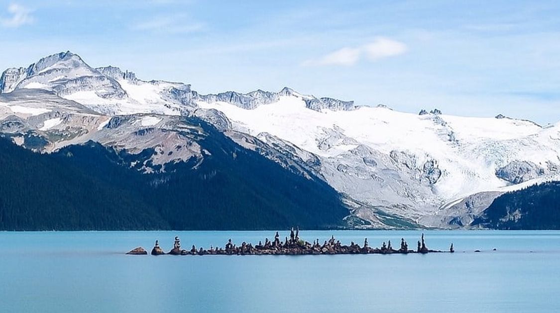
1. Joffre Lakes Hike
This hike may be around a 2.5-hour drive from Vancouver (the furthest away on this list), but it’s so worth it! The trail will wind by not just one lake, but three, keeping you entertained the entire time you’re walking. You can even catch views of Matier Glacier and soaring peaks from the north side of upper Joffre Lake. To make matters better, the quintessential bright Canadian blue hues cloak upper Joffre Lake!
Side note: Some people bring towels and swimsuits here, but know that this lake is fed by the glacier, making for a pretty chilly dip.
Where? Joffre Lakes Provincial Park (Whistler)
Length: 11.8 km
Time: 3.5-6 hours
Elevation: 393m
Difficulty: Intermediate
Distance from Vancouver: 2.5 hours
Getting there: From Vancouver, head towards BC-99 N to Squamish-Lillooet. Travel along this road for a while—it gets twisty—before turning right. You’ll see a sign for Joffre Lakes Provincial Park! Do note that this parking lot fills up fast, so aim to get here early and check BC Parks for the latest access rules before you go. BC Parks day-use passes
Read the Joffre Lakes Hike Guide.

Joffre Lakes Trail
2. Stawamus Chief Hike
This hike packs a punch when it comes to keeping boredom at bay! It winds to three different peaks while getting you to do a quick scramble and use chains. If you’re pressed for time, skip the first peak since that one is the busiest, and the views aren’t as intoxicating as the last two pinnacles. Admire views of Mount Garibaldi and the Tantalus Range!
Where? Stawamus Chief Provincial Park (Squamish)
Length: 6.3 km
Time: 2.5-4 hours
Elevation: 494 m
Difficulty: Intermediate
Distance from Vancouver: 1 hour
Getting there: Take Highway #99 past Horseshoe Bay and towards Squamish. Continue driving along this highway for another 35 minutes. Keep your eye out for signs for Shannon Falls. Quick tip: If you go a few seconds past the Shannon Falls lot, you’ll find the Stawamus Chief Provincial Park parking lot, where you can park for free.
Read the Stawamus Chief Hike Guide.

Stawamus Chief Trail
3. St. Mark’s Summit Hike
Encounter magnificent views of Howe Sound, Vancouver Island, and the Tantalus Range upon arriving at St. Mark’s Summit. The hike doesn’t demand you to work too hard, placing it in the prestigious high-reward-for-little-effort category. It will still propel some exasperated breaths, but hey, sometimes walking up a short flight of stairs in the morning has the same outcome.
Where? Cypress Park (North Shore)
Length: 11 km
Time: 5 hours
Elevation: 460 m
Difficulty: Intermediate
Distance from Vancouver: 45 minutes
Getting there: Head to Cypress Mountain parking lot. To get here, go on Highway #1 (west) and turn onto Exit #8, which leads to Cypress Bowl Road. Drive along this highway for 15 km. Eventually, you’ll reach the downhill ski parking lot.
Read the St. Mark’s Summit Hike Guide.

St. Mark’s Summit Trail
4. Mount Seymour Hike
Embroidered with city views contrasted with ocean hues and layers and layers of rolling mountain peaks, this hike will make you feel like you’ve fallen into an outdoor wonderland. But, in reality, you’re only 50 minutes from the city! The Mount Seymour Hike gives you the option to choose your destination, whether that be Pump Peak, Tim Jones Peak, or Mount Seymour Peak, but most choose the latter. Even though the route to Seymour also includes a pitstop at Tim Jones Peak!
Where? Mount Seymour Provincial Park (North Shore)
Length: 8.1 km
Time: 3-5 hours
Elevation: 606 m
Difficulty: Intermediate
Distance from Vancouver: 50 mins
Getting there: From North Vancouver, head on Keith Road E to Lillooet Road. Follow Lillooet Road, and take a right onto Spur 4. Turn left to continue along Spur 4. Eventually, the parking lot will emerge on your right.
Read the Mount Seymour Hike Guide.

Mount Seymour Trail
5. Eagle Bluffs Hike
Expect to work hard, but for a short period as you wind along switchbacks to Black Mountain. This hike snakes by a couple of lakes and unveils stunning views of the Lions and Brunswick Mountain!
Where? Cypress Provincial Park (North Shore)
Length: 8 km
Time: 4 hours
Elevation: 350 m
Difficulty: Intermediate
Distance from Vancouver: 45 mins
Getting there: Head towards the Cypress Ski Mountain area. To get here, drive along Highway #1 and take Exit #8 for Cypress Provincial Park. Keep right and stay on Cypress Parkway. Once the ski hills emerge into view, keep left and drive until you reach the parking lot.
Read the Eagle Bluffs Hike Guide.
6. Mount Cheam Hike
You may have to work hard to reach the trailhead, but your rugged drive along Forest Service Road will be rewarded. Well, you’ll have to hike a couple of hours first, and then you can reap the benefits. You won’t be disappointed, though! This route takes you high above the rest of the world, where a panoramic view of Fraser Valley, Jones Lake, Mount Baker, and Lady Peak will take your breath away.
Where? Fraser Valley
Length: 9.5 km
Time: 4.5 hours
Elevation: 700 m
Difficulty: Intermediate
Distance from Vancouver: 2 hours and 45 mins
Getting there: Be sure to have a 4-wheel drive vehicle as the road leading to the trailhead can be quite rugged! From Vancouver, drive along Highway #1 east for around 90 km. Take Exit #119 Sardis, and turn right. Drive along Vedder Road (south). Eventually, you’ll come across a three-way intersection. Take a left. 28 km later, turn left again onto Foley Creek Forestry Service Road. Travel for 2 km. Once you cross the bridge, take a left at the junction, and continue for another 2 km. Take a right onto Chipmunk Creek Forest Service Road. This is where it gets rough! Continue along the gravel road for 8 km until you get to the parking area.
Read the Mount Cheam Hike Guide.
7. Tunnel Bluffs Hike
In 2020, new parking restrictions limited locals and visitors from parking in the parking lot for more than 30 minutes. Have you ever completed an 11.5 km hike in less than 30 minutes? Probably not. Thankfully, we’ve provided an alternative route for this popular hike! Our guide takes you to a parking lot that offers a limited number of paid spots, but at least you can give this trail a try, and it’s definitely worth it. Lions Bay parking rules
It unveils a picturesque view over Howe Sound without asking you to put in too much effort.
Where? Near Lion’s Bay (Squamish)
Length: 11.5 km
Time: 3.5-5 hours
Elevation: 467 m
Difficulty: Intermediate
Distance from Vancouver: 40 minutes
Getting there: Take the Lions Bay Ave exit, and merge onto Oceanview Road before turning left onto Crosscreek Road. Continue until turning right onto Centre Road and then left onto Bayview Road. Turn left on Sunset Drive once you reach the end of Bayview Road. You’ll find a limited amount of parking spots (paid) at the end of Sunset Drive.
Read the Tunnel Bluffs Hike Guide.

Tunnel Bluffs Hike
8. Elfin Lakes Hike
The Elfin Lakes Hike sits somewhere between a fantastic day hike and a rewarding, challenging excursion, making it an ideal candidate for one of Vancouver's best hikes. The trail snakes to two glistening lakes backed by snow-capped mountains. This hike is phenomenal, but remember that it is physically demanding!
Where? Garibaldi Provincial Park (Squamish)
Length: 20.6 km
Time: 4-6 hours
Elevation: 694 m
Difficulty: Upper intermediate-challenging
Distance from Vancouver: 1 hour and 45 minutes
Getting there: Get to Highway #99 and drive north. When you are going through Squamish, you’ll see a BC Parks sign for Garibaldi Park Diamond Head. Take a right here. You’ll follow a gravel road. Another sign will soon come into view, directing you to take a left for Garibaldi Park Diamond Head.
Read the Elfin Lakes Hike Guide.

Elfin Lakes Trail
Best Day Hikes around Vancouver
Get ready for a long day of winding in and out of shady forests and walking by a neverending reel of magnificent views. The following hikes will swallow you into a world far away from the hustle and bustle taking place under Vancouver’s city lights. So tie up your boots, pack some high-calorie snacks, bring a water filter, lots of water, and spend hours immersed in the wild!
You can turn some of these hikes into a 2-day trip, but they can be completed as day hikes.
9. Garibaldi Lake Hike
Tough, long, and stunning, the Garibaldi Lake Hike could easily fall under the 'best,' 'challenging,' and 'day' hikes listed in this article. This route winds through lush forest greenery, grassy meadows, along Rubble Creek, and eventually Garibaldi Lake, tucked below snow-dusted mountains and cloaked in a rich turquoise hue. It's truly an outdoor paradise! You can turn this into a 2-day trek by staying at Taylor Meadows Campground or Garibaldi Lake Campground.
Where? Garibaldi Provincial Park (Whistler)
Length: 18.3 km
Time: 5-7 hours
Elevation: 1073 m
Difficulty: Challenging
Distance from Vancouver: 1 hour and 45 minutes
Getting there: This is a popular route, so be sure to leave early! To get to the trailhead, drive along the Sea to Sky Highway (south). After 25 km, take a left onto Daisy Lake Road. You’ll see a sign for the Black Tusk turnoff for Garibaldi Provincial Park. Follow this road for 3 km (it’s narrow) until the trailhead emerges into view!
Read the Garibaldi Lake Hike Guide.

Garibaldi Lake Trail
10. Crown Mountain Hike
You may be thinking to yourself: this hike is only 9.8 km with a 385 m elevation? That won’t take me 7 hours! Well, we’re here to tell you to leave some time for this hike. Basically, you have to climb the same elevation twice, but don’t worry, the pain is worth it. The trail also takes you down a steep descent when you start the section towards Crown Pass. But in the end, you’ll stand tall on Crown Mountain, eyeing the layers of mountain coating the backdrop across the valley from up high!
Where? Lynn Headwaters Regional Park (North Shore)
Length: 9.8 km
Time: 7 hours
Elevation: 385 m (you take the gondola up first and then start the hike)
Difficulty: Challenging
Distance from Vancouver: 30 minutes
Getting there: If you’re coming from downtown Vancouver, head to Georgia Street and go west. The road eventually becomes the Stanley Park Causeway. Drive over the Lions Gate Bridge and take the first exit—on your right—for North Vancouver. Go into the left lane and turn left at the first set of traffic lights. This takes you to Capilano Road. Continue along this road (north) until you pass Capilano Suspension Bridge. Drive up the hill until you reach the Grouse Mountain Skyride!
Read the Crown Mountain Hike Guide.
11. Panorama Ridge Hike
This is probably one of the best hikes in all of Canada! While it’s long, punishing, and tough, the pinnacle unveils a painting-like scenery that emulates a masterpiece: the ever-so bright blue Garibaldi Lake nestled in a valley of snow-swept mountains. You can turn this into a two-day experience by staying at Taylor Meadows Campground, but be sure to book your site well in advance through BC Parks!
Where? Garibaldi Provincial Park (Whistler)
Length: 30.9 km
Time: 9-12 hours
Elevation: 1810 m
Difficulty: Challenging
Distance from Vancouver: 1 hour and 45 minutes
Getting there: Head to the Sea to Sky Highway. Drive along the highway before taking a left onto Daisy Lake Road. From here, you’ll see a sign indicating where to turn off for Garibaldi Provincial Park (Black Tusk turn-off). Continue along the narrow road until you get to the trailhead (3 km). Be sure to leave early.
Read the Panorama Ridge Hike Guide.

Panorama Ridge Hike
12. Diez Vistas Hike
Spend most of the day immersed in nature without having to exert yourself too much! Fun fact: Diez Vistas means ten views. With this in mind, you know you’re in for a hiking rendition of a treat. The best vista grants you with a bird's eye view of the Indian Arm! The city of Vancouver sits faded in the distance. Admire the three soaring peaks of Mount Seymour, too. What’s not to love about this day hike? Great views (10, to be exact), and long, pleasant day amid nature! It’s a win-win.
Where? Buntzen Lake area (Anmore)
Length: 14 km
Time: 6-7 hours
Elevation: 460 m
Difficulty: Intermediate
Distance from Vancouver: 1 hour
Getting there: The trail begins from the Buntzen Lake parking lot, which is located around 30 km Vancouver. From Vancouver, you’ll make your way to Highway #1 E. Drive along here until you take Exit #44 via the right lane. Stay right at the fork and follow signs for Coquitlam City Centre/BC-7 E. You’ll soon merge onto Lougheed Hwy/BC-7. Stay right as you drive along this road before turning left onto Barnet Hwy/BC-7A (look for signs for Port Moody). Take a right onto Johnson Street, turn left onto David Ave., turn right onto Forest Park Way, turn left onto Aspenwood Drive, and continue straight before turning onto Sunnyside Road. Then turn left, and your destination will be there! (So many turns in this one!)
Read the Diez Vistas Hike Guide.
13. Watersprite Lake Hike
This hike was once regarded as Squamish's hidden jewel but has since gained some popularity, and for good reason: the Watersprite Lake Hike doesn't cheap out on views. With fairy-tale-like lake encounters surrounded by an area of peaks: Dreadnought Peak (1994 m) to the left, Watersprite Tower (1810 m) straight across, and Martin Peak (1877 m). You'll also have a chance to admire the array of mountains fading into the background. This hike is a worthwhile beauty!
Where? Squamish
Length: 17.1 km
Time: 6-9 hours
Elevation: 996 m
Difficulty: Intermediate-challenging
Distance from Vancouver: 1 hour and 45 minutes
Getting there: You’ll need a 4x4 vehicle to get to this trailhead! Take the Sea to Sky Highway towards Squamish, and take a right just after the parking lot for Stawamus Chief take a right onto Mamquam River Forest Service Road. You’ll eventually reach a bridge, go left over it, and ignore the pullout to your left. Continue driving and go right over the next bridge. There�’s a junction here! Take a left before reaching another junction after 16 km of driving, where you’ll take another left.
Read the Watersprite Lake Hike Guide.
Watersprite Lake Trail
14. Howe Sound Crest Trail Hike
Are you a hiking fanatic?! This hike is tailor-made for enthusiasts (and experts) like you! Expect to traverse a surplus of summits, but all the while, views of Howe Sound, The Lions, and bright blue Deeks Lakes will enrapture you! It’s possible to do this 30.1 km hike in one day, but there’s always the option to chill at a backcountry campground overnight. Consider looking into Plateau above Enchantment Lake, Magnesia Meadows, Brunswick Lake, or Deeks Lake for campground options.
Where? Howe Sound (North Shore)
Length: 30.1 km
Time: 12-14 hours
Elevation: 1776 m
Difficulty: Challenging
Distance from Vancouver: 1 hour
Getting there: Take the TC/BC-1 W ramp towards West Vancouver/Whistler (if you’re coming from North Vancouver). Follow this road for 9 km before taking Exit #8 and merging onto Cypress Bowl Road. Park your car in the parking lot by the ski lodge!
Read the Howe Sound Crest Trail Hike Guide.

Howe Sound Crest Trail
Best Challenging Hikes around Vancouver
What makes a challenging hike? There are many factors: exposure, technical terrain, steep incline all work to elevate the 'challenge' level! These hikes are a jumble of all of these factors! Most are long with steep slopes and will have you panting, but the staggering vistas of the ocean, layers of peaks, and cliff faces make the pain all worth it. Dare to take a look at the challenging hikes below and choose your favourite!
15. Black Tusk Hike
Incredibly scenic, this 26.1 km out-and-back route unveils a collage of staggering views, keeping your eyes immersed in beauty while your legs work hard. The Black Tusk hike winds to a fantastic overlook of Garibaldi Provincial Park and the enchanting Garibaldi Lake.
Where? Garibaldi Provincial Park (Whistler)
Length: 26.1 km
Time: 9-12 hours
Elevation: 1393 m
Difficulty: Challenging
Distance from Vancouver: 1 hour and 45 minutes
Getting there: Follow the Sea to Sky Highway until taking a left onto Daisy Lake Road. You’ll see a sign for the turnoff for Black Tusk at Garibaldi Provincial Park. Go for 3 km more until you reach the trailhead. Get here early!
Read the Black Tusk Hike Guide.

Black Tusk Trail
16. Grouse Grind Hike
Don’t let the short length fool you; this is a challenging hike that has you elevating almost 800 m within 2.5 km. It’s a sure-fire way to get your heart pumping! But not only will you be travelling upward, but you’ll also have to climb up wooden stairs for most of the hike. Talk about a grind! This is an excellent hike for those who want to get some exercise and enjoy nature before continuing with their day. Grouse Grind FAQ
Where? Grouse Mountain (North Shore)
Length: 2.5 km
Time: 2-2.5 hours
Elevation: 800 m
Distance from Vancouver: 30 minutes
Getting there: Follow Highway #1 and head west. Go across the IronWorkers Memorial Bridge towards North Vancouver. Look for the Capilano Road Exit. After taking this exit, turn right. This takes you to Capilano Road. Continue driving north until you reach the parking lot!
Read the Grouse Grind Hike Guide.

Grouse Grind Trail
17. The Lions Binkert Trail
Hike atop one of Vancouver’s famed natural wonders: The Lions. From the pinnacle, you’ll get the chance to admire one of the most revealing images of the Vancouver region. It’s truly a spectacle! But note that this hike isn’t for the faint of heart, it’s a steep hike with rugged terrain, and sometimes snow can linger on this trail deep into the summer months.
Where? Howe Sound (North Shore)
Length: 15 km
Time: 8 hours
Elevation: 1280 m
Distance from Vancouver: 40 minutes
Getting there: Before you go, know that this is a challenging hike and shouldn’t be attempted by beginners. Be sure to look at safety precautions before stepping into your vehicle and driving here. Once you’re in your car, head to Highway #1. Go towards Horseshoe Bay, and eventually, you’ll turn onto Highway #99 (Sea to Sky Highway). Follow this highway until you arrive in Lions Bay, a small town. Take the Lions Bay Avenue exit and make a quick left. This takes you to Cross Creek Road. Follow the bridge across Harvey Creek before merging onto Centre Road. Turn left onto Bayview Road and then take another left onto Mountain Drive. Go left again at Sunset Drive and park at the yellow gate. Keep in mind that you’ll have to pay $3 an hour for parking, or $24 per day.
Read the Lions Binkert Trail Hike Guide.
18. Coliseum Mountain Hike
This mesmerizing hike immerses you into a natural oasis. Encounter a waterfall (Norvan Falls), snow-capped peaks in the distance, and layers and layers of mountains blending into the horizon. This hike can be muddy, so it’s a good idea to bring along gaiters.
Where? Lynn Headwaters Regional Park (North Shore)
Length: 22.7 km
Time: 8.5-11 hours
Elevation: 1277 m
Distance from Vancouver: 40 minutes
Getting there: Head to Highway #1 (west) and take exit #19—Lynn Valley Road. Follow this road until you reach Lynn Headwaters Regional Park parking lots. Be sure to double-check parking rules and current park notices as this is a super long day hike (but so worth it). Lynn Headwaters Regional Park
Read the Coliseum Mountain Hike Guide.

Coliseum Mountain Trail
19. Opal Cone Hike
While this route isn’t super technical, it’s long, requiring hikers to be super fit! Several people stop and camp at Elfin Lake Campground, but if you want a real challenge, you can try to hike this 35 km route in a day, starting from Diamond Head parking lot. Either way, the staggering views will induce a momentary state of awe. Discover bright blue pools tucked in front of soaring mountains and staggering valleys carved with a snaking river.
Where? Garibaldi Provincial Park (Squamish)
Length: 35.2 km
Time: 12+hours
Elevation: 1225 m
Distance from Vancouver: 1 hour and 45 minutes
Getting there: Head to Highway #99 and go towards Squamish. Once you're in town, look for a sign that says 'Garibaldi Park Diamond Head.' Exit here. This takes you to Mamquam Road. Turn left at the next sign for Garibaldi Park Diamond Head. After 10 minutes of driving, you'll arrive at the parking lot.
Read the Opal Cone Hike Guide.

Opal Cone Trail
20. Wedgemount Lake Hike
Skip the Stairmaster and do the Wedgemount Lake Hike instead! While this hike is extremely difficult physically (and relatively easy technically), the supernatural views offer an unparalleled perspective of Canada’s backyard. The vibrant turquoise colour coating Wedgemount Lake will have your jaw dropped and your camera snapping. It’s so stunning here!
Where? Garibaldi Provincial Park (Whistler)
Length: 15.6 km
Time: 6-8 hours
Elevation: 1375 m
Distance from Vancouver: about 2 hours
Getting there: Drive along the Sea to Sky Highway north toward Whistler. Once you pass Green Lake, look for signs for the Wedgemount Lake parking lot and trailhead.
Read the Wedgemount Lake Hike Guide.

Wedgemount Lake Trail
Best Easy Hikes around Vancouver
Not in the mood to heave as you twist high into the trees? Try out some easy hikes that can also translate as family-friendly excursions. The walks below are the perfect option for those craving a quick getaway from the city. Expect pleasant meanders while a supercut of Vancouver’s scenic highlights plays before your eyes!
21. Dog Mountain Hike
The Dog Mountain Hike may be short, but it doesn’t compromise on stunning views. From the top, hikers are guaranteed a theatre of outstanding views of Mount Baker, the Lower Mainland, Fraser Valley, Stanley Park, Strait of Georgia. That’s a lot of vistas for such a short walk!
Where? Mount Seymour Provincial Park (North Shore)
Length: 4.9 km
Time: 1-2.5 hours
Elevation: 240 m
Distance from Vancouver: 50 minutes
Getting there: Get to Highway #1 and take the exit for Mount Seymour. Follow Mount Seymour Parkway until you reach a sign for Mount Seymour Road. Turn left and continue along this road. You’ll soon arrive at the ski hill—park in the northern area of the top parking lot.
Read the Dog Mountain Hike Guide.

Dog Mountain Hike
22. Norvan Falls Hike
Let the forest blow away your worries on this pleasant nature walk to Norvan Falls. You’ll spend most of the hike meandering by Lynn Creek until you reach the lovely Norvan Falls at the end. Breathe in the scenery before turning around and heading back along this relatively flat trail!
Where? Lynn Headwaters Regional Park (North Shore)
Length: 14 km
Time: 4-6 hours
Elevation: 391 m
Distance from Vancouver: 40 minutes
Getting there: If you’re leaving from North Vancouver, drive towards Fern Street. The road eventually becomes Lillooet Road. You’ll have to make a slight left to remain on this road. After 10.3 km, you’ll reach the Norvan Falls parking lot.
Read the Norvan Falls Hike Guide.

Norvan Falls Hike
23. Lost Lake Hike
This pleasant meander follows either a gravel path or a more secluded route (your choice) to a small glimmering lake! Bring your bathing suit and some snacks for a munch at one of the picnic tables surrounding the lake. Admire views of Blackcomb and Whistler Mountains as you walk!
Where? Whistler
Length: 5.1 km
Time: 1-2 hours
Elevation: 120 m
Distance from Vancouver: 1 hour and 45 minutes
Getting there: Start by parking in one of the public parking lots in Whistler Village. To reach the start of the hike, walk to parking lot 5. You’ll see signs for Lost Lake.
Read the Lost Lake Hike Guide.

Lost Lake Hike
24. Squamish Smoke Bluffs Hike
The Squamish Smoke Bluffs Hike is the ultimate family-friendly outing! After around 600 m after walking, a playground will emerge. Stop and let your kids play before continuing (if you want to, of course). Do note that you will come across wooden stairs, so this isn’t a hike meant for families with strollers. The best part about Squamish Smoke Bluffs Park is that there are several trails to choose from. Take advantage of this and create your own adventure while you’re here!
Where? Squamish Smoke Bluffs Park
Length: 3.5 km
Time: 1-2 hours
Elevation: 223 m
Distance from Vancouver: 1 hour
Getting there: Head to Squamish. Once you reach the main intersection downtown, turn right. This takes you to Loggers Lane. Continue along this road until you arrive at a crossroads, where you can see a sign for Smoke Bluffs Park. Take a right into the parking lot.
While you can explore several trails in Squamish Smoke Bluffs Park, it may still be worth checking out this route guide for Squamish Smoke Bluffs Hike, which matches the distance, length, and elevation numbers shared above.

Squamish Smoke Bluffs Hike
Want more family-friendly hikes around Vancouver? We have a full list of easy hikes around Vancouver suitable for most ages.
You might also want to explore more day hikes around Vancouver, North Shore hikes, and Sea to Sky trail guides before you go.
Which of these 24 hikes stands out to you? We’re excited for you to tie up your hiking shoes and explore the otherworldly views surrounding Vancouver!
Tours in British Columbia
BC has some epic hiking and paddling tours, and you can see all the tours in BC on 10Adventures to find the perfect one for you!
Articles about Trip Planning to the Canada's West Coast
If you have a big task on your hands to plan a trip to the West Coast of Canada, look no further! Check out the list below to find all the information that you might need.
Planning your West Coast Trip
- Planning your trip to Squamish
- Planning your trip to Strathcona Provincial Park
- Planning your trip to Victoria
- Planning your trip to Whistler
Vancouver and Sea to Sky Articles
- Easy Family Hikes around Vancouver
- Greatest Dayhikes around Vancouver
- Planning your Winter Weekend in Whistler
- Winter Adventures near Vancouver
Vancouver Island Articles
Lynn Campbell
Apr 13, 2026
Lynn is the co-Founder of 10Adventures. She had never slept outside until she was 28 years old, and now is an ardent hiker, backpacker, traveller, and bike tourer!
Recent stories
Destinations
Netherlands Bike Trips: Best Cycling Routes and Tours for 2026
Netherlands bike trips are among the easiest and most enjoyable cycling holidays in Europe.
Lynn Campbell
Jul 7, 2026
Destinations
Chile Biking Tours: Best Cycling Routes and Trips for 2026
Chile biking tours are some of the most dramatic cycling experiences in South America.
Nadine Gravis
Jul 7, 2026
Booking resources
Booking with 10Adventures: How It Works and What to Expect
Life is stressful enough.
Richard Campbell
Jul 6, 2026