
BlogDestinationsThree Passes Trek – The Full Guide and Detailed Itinerary for 2026
Three Passes Trek – The Full Guide and Detailed Itinerary for 2026
Table of contents

Richard Campbell
May 16, 2026
Richard is the Founder of 10Adventures, and as a writer shares his experience from 30+ years exploring the world by foot, bike, ski, and boat.
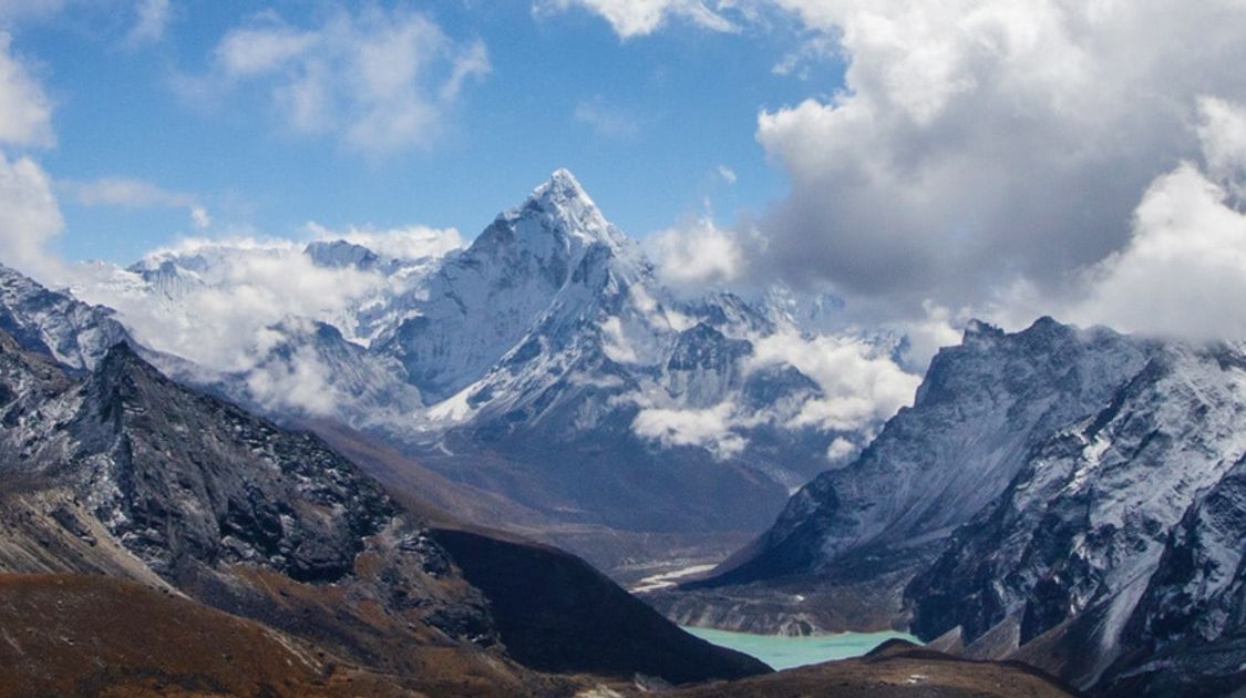
The Everest region is one of Nepal’s top trekking destinations, with the Three Passes Trek being the ultimate challenging destination. You cross three passes over 5,000 m, each offering panoramic views of some of the world’s highest mountains. This adventure in the Himalayas gives you a unique experience in terms of the vistas and culture of the Sherpa people. Browse Guided Everest Trekking Tours on 10Adventures for the full range of guided options in the Everest region.


What to Expect on the Three Passes Trek in 2026
Planning the Three Passes Trek for 2026? Here is what to know before you go:
- Permits required: You need three permits; the TIMS card (NRs 3,000 for TAASC agency trekkers; NRs 6,000 independent), the Sagarmatha National Park entry fee (NRs 3,500) and the Khumbu Pasang Lhamu Rural Municipality fee (NRs 2,000). Purchase the TIMS card in Kathmandu before departure. The national park and municipality permits can be bought at checkpoints en route.
- Flights to Lukla: During peak spring season (April to May), domestic flights to Lukla frequently depart from Ramechhap Airport rather than Kathmandu, due to congestion at Tribhuvan International Airport. Ramechhap is a 5 to 6 hour drive from Kathmandu. Factor this into your schedule and book bus transfers in advance.
- Best seasons: Spring (March to May) and autumn (September to November) offer the clearest skies and most stable conditions. April and May bring rhododendron blooms at lower elevations. Avoid the monsoon (June to August) when trails are muddy and the risk of leeches and landslides is high.
- Guided tours: 10Adventures does not have a specific Three Passes Trek tour. The closest option is the Guided Everest Base Camp and Gokyo Lakes Trek, a 21-day journey covering the Gokyo lakes and Everest Base Camp. See the Tour section below for details.
- Difficulty and gear: The highest pass, Khongma La, reaches 5,535 m. Cho La may require crampons in snowy conditions; carry microspikes at minimum. Previous high-altitude trekking experience is strongly recommended before attempting this route.
- Solo trekking: Nepal Tourism Board has confirmed that trekkers do not require a mandatory guide in open areas including the Everest region as of 2026. The Solukhumbu municipality has specifically stated it welcomes independent trekkers. Always verify permit requirements before departure as regulations can change.
Three Passes Trek Details
- Difficulty: Challenging
- Highest Elevation: Khongma La Pass at 5,535 m
- Total elevation gain: 8,100 m
- Total elevation loss: 8,079 m
- Time: 14–15 days
- Closest Major City: Lukla
- Permits: TIMS Card, Sagarmatha National Park Permit
- Accommodation: Mostly teahouses
- When to Do: Spring (March to May) and Autumn (September to November)

Three Passes Trek: Detailed Itinerary
Imagine spending two weeks deep in the remote Himalayas, pushing past the limits of your comfort zone, and trekking among the world’s most epic peaks. The Three Passes Trek will challenge you as you hike through peaks and valleys, staying at teahouses along the way for a quick rest between long hiking days. Embark on the journey of a lifetime on the most exhilarating trails crossing glaciers and reaching breathtaking heights.

Day 1: Flight to Lukla; Trek to Phakding
After landing in what is considered to be one of the world’s most dangerous airports, Lukla (2,860 m), you find your way through the crammed market in the small town. This is a relatively easy first-day hike covering 6.7 km from Lukla to Phakding (2,640 m). Interestingly, the elevation loss is more than the elevation gain. You’ll be losing about 496 m and gaining around 287 m along the way. The hike should take around 3–4 hours, depending on the level of fitness.
Pass the notable Pasang Lhamu Memorial Gate after showing all the required permits at the counter just before the gate. Follow the path and head towards the Dudh Koshi valley leading to a small settlement known as Chheplung. Many teahouses and small shops are present in Chheplung, where the locals give you a warm smile signaling you to come to their shop. The trail has a copious amount of small stupas and mani stone, a black boulder engraved with Buddhist mantras. It is considered religious to the Buddhists, and you’re supposed to walk on the left side of it.
After leaving Chheplung, follow the riverside trail passing over a suspension bridge. Descending for about 500 m from Chheplung takes you to Thado Koshi, your lunch stop for the day. Enjoy your meal with spectacular views of the surrounding mountains. After crossing several metal suspension bridges over the Dudh Koshi river, you get to Ghat, a village with the Yunging Gompa. Walk past the large gumba and wash your sins away by turning the prayer wheels. A large stunning mani wall is also present as you leave the gumba behind.
Walking for another 30-35 minutes uphill takes you to Phakding. Phakding is a large village with teahouses and lodges on either side of the river. You’ll be surprised to find that this village has everything you fancy. Wi-Fi cafes, luxurious coffee shops, pool houses, and trekking equipment, you name it, they have it all. Continue for another 5-10 minutes and get to the other side of the river, crossing a suspension bridge to avoid the overcrowded lodges in the main bazaar. Just after you finish crossing the bridge, you’ll see a signboard that says to go left for Mountain Lodge. Stay at Mountain Lodge in Phakding for the night. The place is secluded, and still, you can take in all the beauty of the village. The rooms are very comfortable, and you also get a hot shower for an extra charge. They also have arrangements for camping if you’re up for it. Camping is more fun as you get to sleep next to the soothing sound of the flowing river.
Day 2: Trek to Namche Bazaar
Wake up to the sight of the emerging sun gradually warming up Phakding. Kick-off your day with a hearty breakfast as you have to cover about 11.2 km hiking from Phakding to Namche Bazaar (3,440 m). The elevation gain today is about 1,467 m, whereas the elevation loss is at 651 m. The trails are diverse today as you walk up and down following the same Dudh Koshi valley. The uphill climb to Namche is particularly strenuous as the whole climb entails having to walk on stone steps for its entirety.
Come down from the Mountain Lodge and take a left to be in the main EBC trekking route. The sound the river makes when it hits the huge rocks and boulders is quite fascinating to hear. Although the path is easy and flat when you start, it is constantly populated by incoming mules carrying loads of luggage and goods. You encounter a huge waterfall on the way, where you can have a moment and take a picture. The trail goes flat until you reach a small village Benkar. Have a cup of tea in one of the teahouses in the village and rest your muscles to endure the upcoming uphill climb. Cross the first suspension bridge just as you leave Benkar with caution as yaks might be coming from the opposite direction, and you have to return to let them pass first. Continue north through the valley in a rocky trail to Monju. Climb the stone steps, and you’ll be in Monju in no time. There is an army checkpoint at Monju. Don’t worry—they record your details to ensure that you have all the permits so that there is no problem higher up. The official Sagarmatha National Park (SNP) area starts here, and you have to buy the TIMS card and SNP permit here to enter the national park area.
From here, the trail descends to a mani stone between two hills and a beautiful view to savor. Walk down the trail until you reach the lunch stop for the day at Jorsalle (2,740 m). Stop at a lodge, order dal bhat and enjoy it with the open view of the Dudh Koshi valley. The uphill walk to Namche just after leaving Jorsalle. Climb up a series of stairs and descend the path just by the riverside. After walking for a few minutes, you see the steep uphill trail that leads to Namche. As you follow the trail, it takes you up the iconic suspension bridge where you see many trekkers stopping to take a photo. There is another suspension bridge underlying the one you’ll be walking, which is the old bridge. After crossing the bridge, it’s two hours straight uphill until Namche Bazaar. There are a lot of alternative shortcuts on this trail, but taking one is not recommended as you might get lost. So, sticking to the main trail is mandatory. Eventually, you come across a viewpoint, from where you can see the Dudh Koshi river with a sequence of hills in the vista—a fantastic sight. This portion before you reach Namche Bazaar is famously known as “Toph Danda.” Since it’s a challenging route, there is a resting place where you witness a lot of backpackers taking a break to catch their breath. From the resting place, it is about an hour’s walk to Namche.
You will easily recognize the famous Namche Bazaar (3,440 m) with a lot of houses built consecutively on the hills. As you enter Namche, you will see a small gumba and an artificial waterfall made by the locals. Stay at Kalapatthar Lodge near the Irish Pub at Namche. Hydrate yourself well and eat some noodle soup as you’re at a relatively high altitude now. Tomorrow is the acclimatizing day where you go for a hike to nearby viewpoints.

Day 3: Acclimatization day in Namche
Rise and shine! Today is the first acclimatization day of your trek. There are a lot of acclimatization hikes around Namche as most trekkers spend a day or two here. The most famous hike is the Tenzing Hillary Viewpoint, also known as Chor Camp. You can see a panorama of mountains from the vantage point while enjoying a cup of tea. Additionally, you can hike up to Khumjung via Syangboche Airport past the Yak farm. Many hikers decide to see the views from the Viewpoint and then go to Kyangjuma (3,700 m), which is on the way to Tengboche.
Ascend the steep stairs from Namche until you reach the army camp. There is a small narrow trail leading up to the Tenzing Hillary Viewpoint. The trail is undemanding, and it takes about one hour to reach the vantage point from where you see phenomenal views of some majestic mountains like Everest, Khangteka, Thamserku, Kusum Khangkaru, Khumbila, Lhoste, Nuptse, Kongde, Tobuche, Cholatse, and Ama Dablam. Take a snap with the huge statue of Tenzing Norgay with the surrounding peaks in the background. You may choose to return to Namche for lunch or head towards Khumjung, which is a further 2–3 hours hike from here. If you decide to go to Khumjung, head northwest towards the famous but unused Syangboche Airport. You will find a fork on the trail on one of the ends of the airport. The left trail will take you to Khunde, and the right one will take you to Khumjung. Khunde is a village above Namche with a small monastery and a hospital known as Hillary Hospital. The hospital was built by Sir Edmund Hillary in 1966 and serves the locals in the surrounding communities. You can go to Khunde first and then head east on a flat trail to get to Khumjung. The teahouses at Khumjung serve good food.
After having lunch at Khumjung, descend to Namche. On the way back, you can visit the Sherpa Museum close to the army camp. The Sherpa Museum is a great place to learn about the Sherpa culture and mountaineering history in the region. You can also observe a collection of equipment related to the first Everest summit. Stay overnight at Namche.
Day 4: Trek to Thame
After a day of acclimatizing hikes and a good rest at Namche, you are ready to set out west to Thame (3,813 m), a beautiful valley with comparatively less populated trails. The hike today is a pleasant one full of majestic views of the mountains and picturesque villages along the way. You’ll walk approx. 8.0 km from Namche, where the elevation gain is 719 m, and the elevation loss is 373 m.
Head up past the monastery at Namche and some splendid mani stones to get to a rocky cliff above the Dudh Koshi valley. Here, you see the vista of Namche Bazaar with mountains like Thamserku and Ama Dablam on the horizon. As you continue the trail, you traverse through a dusty, rocky trail and descend towards the village Phurte (3,390 m). You come across a lot of chhortens and mani walls in between. After passing Phurte, you will ascend until you reach a promontory where you see the village Thamo (3,480 m) with a beautiful monastery. From here, the valley goes up and down, and in no time, you reach Thamo for a lunch break.
After your meal, brace yourself for the steep stairs to the monastery; however, the trail after crossing the monastery is quite flat. Continue on the trail for an hour or so until you reach another village, Samde (3,610 m). Samde is a small village with only a few houses and fields around. The path continues to rise gradually, and you can see clear views of the open valley of Thame Koshi, which is the way to the famous pass Tashi Lapcha. Continuing on the trail, you come across huge, beautiful Buddhist paintings on the boulders. You cross a small bridge over the river and ascend to find yourself on a field divided into separate pieces by the walls. That is when you reach Thame. Thame has two parts; Lower Thame and Thame Teng. The first village you come across is the Lower Thame, whereas to get to Thame Teng, you must climb up a small ridge from Lower Thame and descend to the large settlement. Stay at Summiteers Lodge in Thame Teng and enjoy the views of the surrounding mountains.

Day 5: Trek to Lungden
Wake up to a beautiful landscape surrounded by huge mountains and lush green fields illuminated by the rising sun. The trail to Lungden (4,360 m) is both uphill and downhill, but the walk is quite effortless. Lungden is about 8.7 km north of Thame, where the elevation gain is 648 m, and the loss is 112 m. The trail is less populated with tourists, so this is a great option for those who like serenity on the trails.
Just after leaving Thame, the trail, besides the river, gradually rises as you walk through a dusty and rocky terrain. The tree line slowly diminishes and all that is left is empty barren lands. The next village you reach is Taranga (4,020 m), which has only local houses but no accommodation for travellers. The views of the mountains start to disappear and all the majestic vistas are hidden behind small black ridges. As you leave Taranga, you cross a small bridge and enter Marlung (4,150 m), the last major village before you get to Lungden. Have a snack or go for a hearty lunch here as Lungden is only about an hour from here. After you finish your meal and make your way to Lungden, you ascend the straight path on a rocky trail. Lungden is a small village with a few lodges. Stay at Kongde View Lodge, the first teahouse you see just as you enter Lungden. Take a good rest tonight—tomorrow, you cross your first pass of the trek.
Day 6: Trek to Gokyo via Renjo La Pass
Start early today as this is the day you cross your first pass of the trek, Renjo La. The trail is straightforward as you leave Lungden. The views are not that extraordinary, but once you get moving, the scenery starts to open as you see the valley you walked yesterday. It is all uphill today, and the high altitude makes it more grueling. Today’s total distance is about 10.5 km, and the elevation gain is 1,027 m, whereas the elevation loss is about 636 m. Take occasional breaks and put your bags down to build up your endurance. Also, remember to take a packed lunch from Lungden as there are no lodges or teahouses in between.
You encounter a lot of small yet beautiful lakes on the way. Tall rocky mountains are omnipresent for the whole walk today until you reach the top of the pass. There is a slight chance that you’ll see indigenous animals and birds like the Danphe and Musk Deer if you’re lucky. Keep a consistent pace, and don’t push yourself in the high altitude as you will be above 5,000 m. Just before the last push to the pass, you see a gorgeous body of water that resembles Gokyo Lake. The final ascent is a rocky uphill path with no signs of an easy walk. After climbing for almost an hour and a half, you see a boulder decorated with prayer flags, which is the Renjo La (5,435 m). You see one of the best views of Mt. Everest from the top of the pass along with Gokyo village, Gokyo Lakes, and other mountains like Cho Oyu as well.
The descent from the pass towards Gokyo (4,998 m) is as back-breaking as the ascent. The trail is a steep downhill filled with small unstable rocks, and if you’re not an experienced runner, then brace your knees well. Gokyo village isn’t as near as it seems even though you see the settlement as soon as you start to walk down from the pass. After you finish the descent, you meet a flat trail just beside the largest Gokyo lake (there are 6 lakes in Gokyo). Continue strolling until you reach the teahouse area. Stay at Gokyo Resort for good accommodation, food, and a nice view of the lake. Since you’ve gained considerable altitude, it is necessary to acclimatize and stay in Gokyo tomorrow.

Day 7: Acclimatization day in Gokyo
This is your second acclimatization day of the trek. There are a couple of options to spend your time wisely in Gokyo while acclimatizing. You can either choose to climb Gokyo Ri (5,375 m) early in the morning or hike up to the fourth and fifth lake of Gokyo valley named Thonak Tsho and Ngozumpa Tsho, respectively. The views from Gokyo Ri are similar to that from Renjo La Pass with the only exception of Cholatse Himal, but it does give a sense of accomplishment being at the top of Gokyo Ri. It is up to you to choose what you want to do.
If you decide to go up to Gokyo Ri, you must wake up really early in the morning and reach the top before sunrise. Head to the northwest of Gokyo and cross a small stream and take the uphill trail leading to Gokyo Ri. You’ll meet a lot of trekkers on this trail going up. The trail is a rocky one, and it is about 650 m of a vertical climb from Gokyo to reach Gokyo Ri. The climb is definitely worth it as you can see unbeatable panoramic views of the surrounding peaks illuminated by the rising sun. It takes about 2 hours to climb Gokyo Ri. The picturesque view of the turquoise Gokyo Lake is not to be missed.
The other option is to hike up to the fourth and fifth lake. About 3.0 km north of Gokyo village is the fourth lake with its high cliffs and peaks rising above it. The trail continues to the fifth lake, where you see a mesmerizing view of the shimmering turquoise blue water. There is a small hill at the edge of the lake from where you get astounding views of Cho Oyu, Makalu, Everest, Nuptse, and Lhotse. The northern part of the fifth lake hosts a fabulous view of the Ngozumpa Glacier, which you will cross when you walk to Thangnak. The return trip from the fourth and fifth lake takes 4–5 hours.
Day 8: Trek to Thangnak
Today is a short walk to Thangnak (4,717 m), covering only about 3.8 km with an elevation gain of 131 m and an elevation loss of 171 m, but it is equally a tricky one. You have to walk over the Ngozumpa Glacier to get to Thangnak from Gokyo. The sketchy glaciers are vast and perilous obstacles constantly changing to make your journey even harder. The trail becomes less obvious, and at times, you think you’re lost for the fact that you hardly meet anyone on the trail.
As you make your way up to the glacial moraine after leaving Gokyo, you encounter a maze of rubble piles, dozens of glacial lakes, and sounds made by the moving glacier. You might find it a tad depressing due to the low clouds and fog surrounding you. Crossing the glacier in bad weather will enhance the difficulty. The trails are always changing, and only when you see small stones marked as landmarks, you are relieved that you are in the right direction. It might take up to 2–3 hours to cross the glacier. Continue along the path until you see a group of fluttering prayer flags welcoming you to the other side. Descend from the path of the prayer flags to get to Thangnak. With only a few teahouses, Thangnak is the base to Cho La Pass, whether you’re descending or ascending the pass. Stay at Cho La Resort in Thangnak and slurp down hot noodle soup to vitalize your body for the next pass tomorrow.

Day 9: Trek to Dhzongla via Cho La Pass
It is always ideal to start early if you’re crossing a high pass due to the high winds and unpredictable weather at high altitude. Cho La Pass (5,420 m) is considered the most demanding pass of all the three passes due to the difficult terrain filled with small unsettled rocks. If you’re crossing the pass in bad weather, you might need climbing equipment to triumph the steep and slippery trail. The distance from Thangnak to Dhzongla (4,836 m) is about 7.9 km, with an elevation gain at 785 m and elevation loss at 652 m. As there are no lodges between Thangnak and Dhzongla, it is best to take a packed lunch.
As you come out of the teahouse to start your trek, you will probably see many other hikers going northeast from Thangnak. The trail at the beginning is a gradual uphill yet a narrow one. This trail to Dhzongla via Cho La Pass is icy and covered with snow most of the time, so it is recommended to take extra care while walking. The gradual uphill ends after you reach a small field, with minimal views of the surrounding peaks. The real grueling path starts after you leave the field as you make your way to the steep uphill. The trail is pretty vertical since there are no stairs, and you literally have to walk on the ridges of the tall hills. Climb up on the rocky and slippery trail, steadily taking breaks to catch your breath as you’ll be nearing 5,000 m. The last stages of the trek, before you reach Cho La Pass, test your climbing skills. After a strenuous climb, you reach the top of the pass decorated with colorful prayer flags. Beautiful mountain views surround you, with Ama Dablam seen to the south, Cholatse to the west, and Lobuche peak to the east.
Descending from the pass is not easy either, as you have to walk through crevasses and trails filled with snow. Walk carefully and make your way through the most amazing vantage point of the whole trek. This vantage point marks the start of a steep downhill path. You can see a surreal view of a flowy valley leading to Pheriche village with Mt. Ama Dablam standing strong in the middle. Take a break, put down your bags, and enjoy a packed lunch with this view. From here, the trail descends on a rocky trail. Continue along the main trail to reach Dhzongla. Stay at Maison Sherpa Lodge at Dhzongla. They serve delicious meals and have comfortable rooms.
Day 10: Trek to Lobuche
Today’s short and relatively easy walk is the perfect compensation to yesterday’s tiring and exhausting hike over Cho La Pass. Dhzongla is a secluded village set up in a beautiful location where you can see the towering Taboche Himal and the omnipresent Ama Dablam. You’ll be heading northeast from Dhzongla to get to Lobuche (4,920 m), covering almost 6.3 km, with an elevation gain of 301 m and an elevation loss of 218 m.
Cross a small stream just as you leave Dhzongla. From here, you gain a bit of elevation, and the turquoise lake Cholatse Tsho starts to appear in view with the Taboche and Cholatse mountains rising straight up from it. Continue along the path until you reach a rest point marked with a memorial. Do not divert your way down from the rest point as it is the way to Phortse village. From the rest point, you see a huge valley with a spectacular landscape spread out before you with the Ama Dablam mountain being most prominent. Head north towards the massive glacial moraine that takes you to the main trail of Everest Base Camp. The trail is mostly flat, making for a pleasant walk. You start to see many trekkers on the other side of the valley coming up from Thukla. As you make your way down, the trail crosses a stream, and two trails merge, and you’re on the EBC trail.
A short hike up the valley beside the glacial moraine takes you to Lobuche. You will arrive in Lobuche quite early, so you have the afternoon to yourself. You can either choose to rest in the teahouse or take a hike in the various vantage points in Lobuche. You get excellent views of Pumori and Nuptse to the east from Lobuche. Stay at Alpine Lodge in Lobuche. Tomorrow, you cross the final pass of the trek.

Day 11: Trek to Dingboche via Khongma La Pass
Today, you cross the third and final pass of the trek, Khongma La Pass (5,535 m), which is also the highest pass among the three. As the ritual demands, start early from Lobuche, so you do not have to face the chilling winds at the top of the pass. As there are no teahouses in between, so take a packed lunch with you when leaving Lobuche. The ascent and descent are both challenging as you have to cover about 10 km with an elevation gain of 759 m and an elevation loss of 1,360 m. Experience various terrains to get to Dingboche (4,300 m) as you walk on glacial moraines, icy surfaces, rocky trails, and dusty tracks.
Head east of Lobuche and climb the small ridge above the village to make your way to the unstable Khumbu glacier. Just as the Ngozumpa glacier, the trail through this glacier is constantly changing, so track the path to the other side of the glacial moraines carefully. After crossing the tricky glacial part, you’ll walk on a flat trail until you reach a huge boulder serving as a rest point. After this, it is a vertical uphill with small unsettled rocks spread throughout the trail. You’ll be out of breath constantly, which is justified by the high altitude. This part of the trail is relatively strenuous because of the slippery trails aggravated by rocky surface. Like most of the passes, Khongma La Pass is decorated with a couple of prayer flags tied to huge rocks. Enjoy a spectacular vista of the mountains, including Lhotse, Lhotse Shar, Baruntse, Ama Dablam, Makalu, and many others. Just a few metres below the pass is a vast turquoise lake that complements the whole scenery.
Descend from the pass and stop by the lake for your lunch break. This lake is mostly frozen, and the trail passes right through the lake at those times. The descent is not as tricky as the ascent, but it is definitely hard on the knees. The trail can be clearly seen unless it is covered with snow. After passing the lake, you get to a large field where you can see the turns and twists of the trails directly against Mt. Ama Dablam. The descent is seemingly endless as you walk through a wide valley surrounded by huge black boulders and glacier-smoothed rocks with Nuptse peeking from behind. Follow the same trail until you reach a fork. From here, you can see the Chhukung village and Dingboche village. Take a right turn and descend until you reach a group of sheds built with black stones. Continue descending and reach the bottom of the trail with a small stream flowing beside it. Finally, the downhill concludes here as you make your way to Dingboche. After walking for about 30 minutes, you reach the large village of Dingboche. Dingboche is the second-largest acclimatization zone in the Khumbu region if you’re trekking to Everest Base Camp. There are a lot of trekking shops, cafes, coffee shops, and pool houses here. Stay at Bright Star Lodge and soak your weary legs in warm water. Congratulate yourself for passing all three passes, and have a hearty dinner.
Day 12: Trek to Tengboche
As you’ve completed all three passes, descend to Tengboche (3,857 m) with pride in your heart. Today’s walk will be much easier because you’re at a lower altitude, and most of the path is downhill. You’ll be back on the main EBC trail today, so the trek will be filled with a considerable number of trekkers. The distance to be covered today is about 9.8 km, with the elevation gain at 296 m and elevation loss at 762 m.
Make your way out of Dingboche by passing through a huge mani stone and walking on a dusty trail. The flat trail leads to a suspension bridge over the Dudh Koshi river. The towering views of Taboche, Ama Dablam, Nuptse, and Lhotse will be present all along the trail until you reach Somarey (4,010 m). Take a break and sip a cup of coffee at Somarey. Stay on the main trail and continue on the same path to reach Pangboche, a principal ancient village in the area. Pangboche accommodates a 16th-century monastery containing famous relics, of which the skull and hand of the Yeti are the most conspicuous. To get to the monastery, you have to go to the upper part of Pangboche, which lies on the opposite side of the trail you’ll be walking. Take a lunch break at Pangboche.
Just as you leave Pangboche, you’ll encounter a huge mani stone. Take a left to reach Lower Pangboche and continue straight ahead, crossing a suspension bridge. The tree line slowly starts to appear as you see rhododendrons and pine trees. Passing through a series of suspension bridges takes you to a deep forest. The trail is completely flat, and you’ll see a couple of small huts in between. After walking on the flat trail for some time, you reach a small village Debuche (3,867 m). Tengboche is just about 10 minutes’ walk from here. There are few teahouses in Debuche, but it is comparatively less crowded than Tengboche. If you prefer to be more secluded, then staying at Debuche is recommended. To get to Tengboche from Debuche, climb a sequence of stairs—it’s more laborious than it looks. Tengboche has a huge monastery that celebrates Mani Rimdu festival during the full moon of November–December. It is an exceptional festival for the locals and equally spectacular for visitors, as well.
Additionally, Tengboche is a fantastic vantage point for Mt. Everest and other surrounding peaks such as Kongde, Nuptse, Lhotse, and Ama Dablam. Stay at Tashi Delek Lodge in Tengboche. The food is excellent, and the lodge has a homey vibe.

Day 13: Trek to Namche Bazaar
Today, you’ll hike to Namche Bazaar from Tengboche. The trail goes down at the start of the trek and heads up again before finally taking a flat surface to reach Namche Bazaar. Dense forests cover the trails, so there is a great chance to see the wildlife of Sagarmatha National Park. You’ll cover about 8.6 km to reach Namche Bazaar with an elevation gain of 665 m and an elevation loss of 1,070 m.
Enjoy the views of the surrounding peaks and visit the monastery at Tengboche. Head south of Tengboche from the “Way to Namche” signboard stuck on a big boulder decorated with Buddhist colours. The trail dives down to the valley below, where it crosses a river and goes right back up. Steep, dusty trails right after leaving Tengboche will really test the strength of your knees. As this part of the trail is quite narrow, you might have to give way to the yaks carrying loads of goods. Finally, when the steep trail ends, you reach Phunki Tenga (3,300 m), where you cross a suspension bridge to get to the other side of the trail. There are lodges on either side of the bridge, and it is best if you take a short break and have refreshments here. Then, the uphill to another small village Leushyasa (3,460 m) starts. This uphill trail is demanding but is the best place to see the Himalayan Monal (Danphe) and Musk Deer. The weather starts to get a bit humid in these parts of the trail. Stop at Leushyasa for lunch.
After leaving Leushyasa, the trail goes up and down until you reach Sanasa (3,600 m). Sanasa is famous for having cozy lodges and many souvenirs for purchase. The locals will greet you with a warm smile and try to sell you the souvenirs here. After Sanasa, a long flat walk leads to Namche with Kyangjuma village (3,610 m) in between. The most difficult part of the trail is from Sanasa to Namche as the trail never seems to end. Take a break and enjoy the serene view of the Dudh Koshi valley with some majestic peaks in the backdrop from Kyangjuma. Kyangjuma is the meeting point of four trails, the first leading to Khumjung, the second to Gokyo, the third to Tengboche, and the fourth to Namche. The directions are marked clearly. Look for the signboard directing to Namche and take that trail. After you leave Kyangjuma, you come across a copious amount of chhortens decorated with fluttering prayer flags, built in the memory of those who lost their lives here. After walking for what seems like forever, you see the army camp at Namche Bazaar. Descend the stairs to get to the main bazaar. Stay at Kalapatthar Lodge and celebrate your success of the three passes with a couple of beers in the local bars at Namche. Don’t drink too much because you cannot afford a hangover, as you have a whole day’s walk to Lukla tomorrow.
Day 14: Trek to Lukla
This is the last day of your trek. You’ll follow the same route as you walked before when coming from Lukla. Although today seems like a doable hike, you will be exhausted by the end of the day. You have to cover almost 16.0 km to get to Lukla. The elevation gain is at 1,015 m, and the elevation loss is at 1,573 m.
Bid farewell to the iconic Namche Bazaar and head south of Namche. The trail plummets down to “Toph Danda” and to the famous suspension bridges. The return trip takes comparatively less time than when you’re ascending the same trail. Descend to Jorsalle and have a tea break. Remember the trail with the mani stone right after Monju when going to Namche? It was a pleasant downhill hike at the time, but now you have to ascend the onerous stairs. It takes more than 30 minutes to conquer the demanding uphill. Pass the village of Monju and cross a suspension bridge to reach Benkar. Continue walking the same trail and reach Phakding, your lunch stop for the day.
After the lunch break at Phakding, descend a stairway to reach Ghat, the village with Yunging Gompa. The trail after Ghat is a mixture of downhill and uphill crossing a series of suspension bridges. The walk is relatively easier until Thado Koshi, but after passing Thado Koshi, the trail gradually climbs up, and it is all uphill from there until you reach Lukla. After a tiring walk, you reach Chheplung, where you can take a short break and have some refreshments. Continue walking on the same trail and reach the Pasang Lhamu Memorial Gate at Lukla, marking the end of your trek. Stay at Khumbu Resort in Lukla. Celebrate your success by going to the Irish Pub at Lukla, famous for having good music and chilled beers.
If you want to trek to Everest Base Camp, it is also possible to hike to Gorakhshep from Lobuche and take a day-hike to the Base Camp. Take as much time as needed for this challenging trek. Some might finish it early, and some might take a bit more time. The time is not the challenge—completing the whole route while also being physically fit and mentally stronger than before is.
Three Passes Trek Map
Best Time To Do the Three Passes Trek
The Three Passes Trek is located in eastern Nepal, an area that enjoys all four seasons. It’s best to avoid mid-winter and mid-summer due to avalanches and mudslides, respectively. The best time to attempt the Three Passes Trek is during autumn (September to November) and spring (March to May).
If you can travel to Nepal for the Three Passes Trek during Autumn, then go for it! The monsoon season during summer will have the vegetation freshly watered and super lush. In fall, the days are warm and clear, and the nights are cool. Spring in Nepal is also ideal for trekking when the weather is warm, but bear in mind that you may have to endure some rainy afternoons.

Accommodation on the Three Passes Trek
While you’re trekking in Nepal, you will most likely stay in accommodation called teahouses. These mountain lodges offer basic amenities a few steps above camping but a notch below a hotel. You’ll find a comfortable bed, shared bathroom, and a shared dining area. Teahouses are super budget-friendly, making a small dent in your wallet anywhere from $3 to $10 per night.
While staying in a teahouse, not only will you have a chance to relax your muscles, but you’ll also meet other like-minded folks trekking the Himalayas. Each teahouse offers a menu with local and western options. To charge your electronics, you’ll pay a small fee, and keep in mind there could be power outages out there. For those looking for a hot shower, especially on a two-week journey like the Three Passes Trek, you can pay a small fee for a quick wash. One guarantee of staying in a teahouse is the undeniably breathtaking views. You’re sleeping in the Himalayas!

Three Passes Trek Costs
Your budget should be around $1035 to $1175 for the Three Passes Trek over 14 days, including transportation, food, permits, visa, guide, and porter.
- Food: $15–$25/day x 14 = $210–$350
- Transportation: $20 (one-way) x 2 = $40
- TIMS card: $8.35
- SNP entry permit: $25
- 30-day visa: $50
- Guide: $30/day x 14 = $420
- Porter: $20/day x 14 = $280
- TOTAL: $1033.35–$1173.35
Three Passes Trek Tour
The Three Passes Trek can be completed on your own by finding guides and porters and handling all the details yourself. For some people, this is part of the joy of travelling. For others, this is a huge hassle, but this can be avoided: sign up with a tour company and let the organization handle all the paperwork.
If you’ve reached this part of the article, trekking in Nepal is probably on your list! Maybe you don’t have time to plan, or you want to enjoy the Himalayas without stressing about details. If that’s the case, check out our Guided Nepal tours. All you need to do is pack your bag! Adventure tour companies help you enjoy your limited vacation time by handling the itinerary for you. It’s a super easy and gratifying way to see the world. Here are some pros and cons to choosing a tour.

Pros of trekking with a tour company
Joining a tour listed on the 10Adventures website means your guides are local, experienced, and thoroughly vetted. We look for companies with trained professionals available to answer your questions, teach you things you wouldn’t learn on your own, and so much more. To make an informed decision, you can read reviews and pick which tour suits you best. Adventure tours are stress-free—you don’t need to think about where you’ll sleep, carry a map, or even think about what you’ll eat (except the occasional snack). Everything is taken care of for you! Just pack up (see our recommended packing list below) and enjoy the extraordinary Himalayas without being burdened by logistics.
Cons of trekking with a tour company
If planning trips sparks joy for you, then a tour may not be a great option. Going on your own gives you flexibility if you feel like staying an extra night or taking a recommended day-hike by a fellow trekker. Avoid the fixed itinerary and plan your own trip. We have a few guides for Nepal on the site to help you get started.
Recommended Three Passes Trek Tour
We don’t have a specific tour for the Three Passes, but the closest option is the Guided Everest Base Camp and Gokyo Lakes Trek, an unforgettable 21-day journey, extending what is normally a 14-day trek into a three-week experience. The tour includes sightseeing in Kathmandu, visiting 6 milky turquoise glacial lakes in the Himalayas, and, of course, getting up-close-and-personal with the majestic beast itself at Everest base camp.
Browse all Guided Everest Region Tours on 10Adventures for the full range of Everest region options.

Adventure Travel Insurance
Any time you travel, there’s risk involved, and travel insurance will protect you and give you that security if anything goes awry. For the adventure tours listed on our marketplace, travel insurance is mandatory, so we recommend purchasing insurance, whether you travel alone or with an organization.
After many years of adventure travel, the 10Adventures team has landed on the insurance provider World Nomads as the go-to. Their values align with ours as an adventure travel company. Other insurance providers don’t always provide coverage for extreme sports, so make sure to read each policy very carefully to ensure proper coverage. We choose World Nomads because some of their policies include coverage for activities like trekking, which is very important to us. No matter which provider you use, travel safely.

Recommended Packing List for the Three Passes Trek
Keeping weight down on multi-day backpacking trips is paramount. Since you’ll stay in teahouses, you won’t have to carry a tent or cooking gear, cutting your pack weight significantly. Here’s a list of what you should pack for your Three Passes Trek. Keep in mind, you’ll have to do a bit of washing after the first week.
Gear + Clothes
- Backpack 50–70 litres with rain cover (try to avoid anything larger, so you’re not tempted to fill the space)
- Sleeping bag
- Sleeping bag liner
- Hiking boots (broken-in and comfortable)
- 5 x Hiking socks (keep 1 clean and dry for nights)
- 5 x Underwear
- 2 x Sports bra (women)
- 2 pairs of trekking pants
- 1 pair of comfy pants for nights
- 2–4 shirts (depending on how often you need to change)
- 2 x Long-sleeve thermal
- Thermal pants
- Packable puffy jacket
- Rain poncho
- Waterproof jacket
- Gloves
- Buff
- Cap
- Quick-dry microfibre camp towel
- Slides (slip-on sandals) for nights in teahouses when you take your boots off

Accessories
- Trekking poles
- Toiletries: toothbrush, toothpaste, hairbrush, soap (shampoo if you want to wash your hair, but most likely, you will wait until the end of the journey to shower!)
- Collapsible water bottle or bladder
- Sunglasses
- First aid kit: sunscreen, band-aids, lip balm, ibuprofen, Imodium
-
- Insider tip: wrap a small roll of duct tape on your trekking pole + use to prevent blisters. Place it on hot spots where blisters may form. Your socks will glide on the duct tape and prevent blisters from forming. Do not put duct tape on already broken skin! That will be very painful to peel off.
- Hand sanitizer
- Headlamp
- Passport + important documents
- Toilet paper (not always available)
- Cash (no ATMs in the mountains)
- Water purification tablets (you can buy purified water, but it is more expensive)
- Electrolytes/Nuun tablets
- Snacks (although you can purchase these along the way, they get more expensive as you get further into the mountains)
- Plastic bags (for wet clothes, dirty laundry, or garbage)

Final thoughts
The Three Passes Trek is one of the more challenging trekking routes in the Himalayas that leads you across glaciers and to altitudes around 5000 m. Whether you attempt it on your own or with an adventure tour, the Three Passes Trek will be imprinted in your memory forever—you will be super proud when you complete this trek. If you are eager to trek, but the Three Passes Trek doesn’t sound quite right, we’ve compiled the best treks in Nepal to help you find a trek to suit your needs. Happy exploring! For more guided Himalayan trekking, browse Guided Nepal Trekking Tours.
Looking to explore the broader Himalaya and Karakoram region? Check out our Guided India tours across Ladakh and the Indian Himalaya, or Guided Pakistan tours for trekking in the legendary Karakoram range.
Trekking in Nepal Articles
Thinking about a trek in Nepal? Check out these guides to learn more and have an incredible trip to the Himalayas.
Nepal Trekking Guides
- Guide to the Best Treks in Nepal
- When is the best time to trek in Nepal
- How to prepare for trekking in Nepal
- Trek in the Himalayas in 2026
Nepal Trekking Route Guides
Richard Campbell
May 16, 2026
Richard is the Founder of 10Adventures, and as a writer shares his experience from 30+ years exploring the world by foot, bike, ski, and boat.
Recent stories
Destinations
Greece Bike Tours: Best Islands, Routes and Trips for 2026
Greece bike tours are one of the most rewarding ways to dive further into the classic postcard views spanning the country.
Nadine Gravis
Jun 30, 2026
Destinations
England Bike Tours: Best Cycling Holidays, Routes and Trips for 2026
A cycling adventure is an incredible way to explore the historic details embedded in England’s countryside in a relaxed and rewarding way.
Lynn Campbell
Jun 30, 2026

Destinations
Iceland’s Volcanic Trails Trek
The guided Volcanic Trails trekking tour is a wonderful alternative to Iceland’s famous and very popular Laugavegur Trail.
Lisa Germany
Jun 28, 2026